















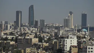
Settlement in Amman dates to the 8th millennium BC at 'Ain Ghazal, home to the world's oldest human statues. During the Iron Age, Rabat Aman was the capital of the Ammonite Kingdom. In the 3rd century BC, the city was conquered by the Greeks and renamed Philadelphia, later part of the Nabataean, and the Roman realms.
In the 7th century, Philadelphia was conquered by the Rashidun Caliphate, who restored its original name. Throughout most of the Islamic era, Amman alternated between periods of relative prosperity and devastation. The city was largely abandoned during the Ottoman period from the 15th century until 1878, when Circassians were resettled there.
Amman grew after it was connected to the Hejaz Railway, and the subsequent formation of its first municipal council in 1909.
Amman witnessed rapid growth after its designation as Transjordan's capital in 1921, receiving migrations from different Jordanian and Levantine cities, and later several successive waves of refugees: Palestinians in 1948 and 1967; Iraqis in 1990 and 2003; and Syrians since 2011. It was initially built on seven hills, but now spans over 19 hills combining 22 areas, which are administered by the Greater Amman Municipality.
Areas of Amman have gained their names from either the hills (jabal) or the valleys (wadi) they occupy, such as Jabal al-Luweibdeh and Wadi Abdoun. East Amman is predominantly filled with historic sites that frequently host cultural activities, while West Amman is more modern and serves as the economic center of the city.
Approximately one million visitors arrived in Amman in 2018, which made it the 89th most-visited city in the world and the 12th most-visited Arab city. Amman has a relatively fast growing economy and it is ranked as a Beta− global city by the Globalization and World Cities Research Network. Moreover, it was named one of the Middle East and North Africa's best cities according to economic, labor, environmental, and socio-cultural factors.
The city is among the most popular locations in the Arab world for multinational corporations to set up their regional offices, alongside Doha and only behind Dubai. Amman has a bus network, including a Bus Rapid Transit (BRT) system that serves the city and connects it to neighboring Zarqa. Amman is served by two airports.
Etymology
Amman derives its name from the ancient people of the Ammonites, whose capital the city had been since the 13th century BC. The Ammonites named it Rabat ʿAmmān (𐤓𐤁𐤕 𐤏𐤌𐤍), with the term Rabat meaning the "Capital" or the "King's Quarters". In the Hebrew Bible, the town is referred to as Rabbaṯ Bənē ʿAmmōn (רַבַּת בְּנֵי עַמּוֹן) or simply Rabbā (רַבָּה), and it appears in English translations as "Rabbah of the Ammonites," "Rabbah of the sons of Ammon, or "Rabbath Ammon." Ptolemy II Philadelphus, the Macedonian ruler of the Ptolemaic Kingdom who reigned from 283 to 246 BC, renamed the city Philadelphia (Ancient Greek: Φιλαδέλφεια; literally: "brotherly love"), after himself, after occupying it.
By the Islamic era, the Rashidun Caliphate restored its ancient Semitic name and called it Amman in the 7th century AD.
History
Prehistoric and Iron Age periods
Neolithic period
The Neolithic site of ʿAin Ghazal today lies in the outskirts of Amman. At its height, around 7000 BC, it had an area of 15 hectares (37 acres) and was inhabited by c. 3,000 people (four to five times the population of contemporary Jericho). At that time, the site was a typical aceramic Neolithic village.
Its houses were rectangular mud-bricked buildings that included a main square living room, whose walls were made up of lime plaster. The site was discovered in 1974 as construction workers were working on a road crossing the area. By 1982, when the excavations started, around 600 meters (2,000 feet) of road ran through the site.
Despite the damage brought by urban expansion, the remains of ʿAin Ghazal provided a wealth of information.
ʿAin Ghazal is well known for a set of small human statues found in 1983, when local archeologists stumbled upon the edge of a large pit containing them. These statues are human figures made with white plaster, with painted eyes. Thirty-two figures were found in two caches, fifteen of them full figures, fifteen busts, and two fragmentary heads. Three of the busts depicted two-headed characters, the significance of which is not clear.
Rabbath Amman
In the 13th century BC, Amman was the capital of the Ammonite Kingdom, and became known as "Rabat Amman". Rabat Amman provided several natural resources to the region, including sandstone and limestone, along with a productive agricultural sector that made it a vital location along the King's Highway, the ancient trade route connecting Egypt with Mesopotamia, Syria and Anatolia.
As with the Edomites and Moabites, trade along this route gave the Ammonites considerable revenue. Milcom is named in the Hebrew Bible as the national god of Rabat Amman. Another ancient deity, Moloch, usually associated with the use of children as offerings, is also mentioned in the Bible as a god of the Ammonites, but this is probably a mistake for Milcom.
However, excavations by archeologists near Amman Civil Airport uncovered a temple, which included an altar containing many human bone fragments. The bones showed evidence of burning, which led to the assumption that the altar functioned as a pyre and used for human sacrifice.
Amman is mentioned several times in the Hebrew Bible. According to the biblical narrative, the Ammonite king Hanun allied with Hadadezer, king of Aram-Zobah, against the United Kingdom of Israel. During the war, Joab, the captain of King David's army, laid siege to Rabbah, Hanun's royal capital, and destroyed it. Hanun's brother, Shobi, was made king in his place, and became a loyal vassal of David.
Hundreds of years later, the prophet Jeremiah foresaw the coming destruction and final desolation of the city. Several Ammonite ruins across Amman exist, such as Rujm Al-Malfouf and some parts of the Amman Citadel. The ruins of Rujm Al-Malfouf consist of a stone watchtower used to ensure the protection of their capital and several store rooms to the east. The city was later conquered by the Assyrians, followed by the Babylonians and the Achaemenid Persians.
Philadelphia
Founding by the Greeks
The conquest of the Near East by the Macedonian Greeks under Alexander the Great in 332 BC introduced Hellenistic culture into the region. After Alexander's death, his empire split among his generals, with the Ptolemies based in Egypt and the Seleucids in Syria. The Ptolemic-Seleucid rivalry, also known as the Syrian Wars, left the region east of the Jordan River a disputed frontier, with Ammon increasing in strategic importance, considering its citadel hill.
The Macedonian ruler of Egypt, Ptolemy II, established a number of cities in the region, including one in Ammon at a site that was initially a military colony, which then developed into a full-blown Greek-type city (polis), possibly by settling there Hellenised Tyrean colonists. Ptolemy II renamed Ammon to Philadelphia (Ancient Greek: Φιλαδέλφεια, Philadelpheia) to honor his own epithet, which he had acquired after having married his older sister, with both being called "Philadelphoi" (Koine Greek: Φιλάδελφοι "Sibling-lovers"). (But the marriage may not have been consummated, since it produced no children.)
Arab Nabataean control and rule
Written sources speak of members of the Jewish Tobiad family based in Jerusalem, who ruled Philadelphia on behalf of the Ptolemies as tax collectors and built a unique palace (today's Qasr al-Abd, 'Castle of the Slave') on the city's southwestern outskirts. Philadelphia switched hands between the Ptolemis and the Seleucids several times, until the 200 BCE victory of the Seleucids at the Battle of Panium.
The Arab Nabataeans exploited the Seleucid-Ptolemic wars to establish their Nabatean Kingdom centered in Raqmu (Petra) in the third century BC, which kept Philadelphia in a border zone. The Nabataeans exercised a form of control in Philadelphia with Seleucid decline in the second century BC. Nabataean presence in the cities of the Decapolis was prominent, with the most substantial archaeological evidence found in Philadelphia, which indicates presence of a large Nabataean community in the city during the first century AD.
Decapolis and flourishing under Roman rule
The Romans conquered much of the Levant under Pompey in 63 BC, inaugurating a period of imperial rule that lasted for four centuries. In the northern parts of modern-day Jordan, the Greek cities of Philadelphia (Amman), Gerasa, Gedara, Pella and Arbila joined with other cities in Palestine and southern parts of today's Syria to form the Decapolis League, an autonomous confederation based on common economic and cultural interests.
The Roman Empire formally annexed the Nabataean Kingdom in AD 106, which it organized as the province of Arabia Petraea, and to which Philadelphia was attached. After the annexation, the Romans under Emperor Trajan constructed around the year 111 the Via Traiana Nova, 'Trajan's New Road', which connected the ancient Red Sea port of Aila (Aqaba) with Bostra, the provincial capital of Arabia Petraea. Philadelphia thrived as a trading center and became an important stop on the new road.
The second century AD saw Philadelphia thriving, with the city being rebuilt in the classical Roman style, with a large theater, a smaller odeon theater, a nymphaeum, public baths, a forum, and a network of colonnaded streets in the valley, as well as a propylaeon with stairs connecting it to the acropolis on Citadel Hill, where a temple dedicated to Hercules was built.
A gymnasium is also believed to have existed in the city, but it has so far not been discovered. The network of colonnaded streets included the usual Roman east–west road known as Decumanus and a north-south road known as Cardo; the remains of neither survive today.
Christian Byzantine rule
With the beginning of the 4th century AD, the Eastern Roman Empire adopted Christianity as the state religion under Constantine, which started the Byzantine period. Knowledge about Philadelphia in the Byzantine period is scant. In the early 300s AD, Greek historian Eusebius noted in the Onomasticon that "Philadelphia was a distinguished city of Arabia." During the Byzantine period, no new walls were constructed at the Citadel Hill, and many churches were built in Philadelphia.
At Quwaysimeh, on the southern edge of Amman, a Roman mausoleum and two Byzantine churches were discovered, with inscriptions honoring wealthy Philadelphians who had donated to build the churches. Philadelphia produced a well-known historian named Malchus in the 5th century AD, an Arab origin scholar who resided in Constantinople and produced a 500-page book about the history of the Byzantine Empire.
Islamic period
Rashidun Caliphate
In the 630s, the Rashidun Caliphate conquered the region from the Byzantines, beginning the Islamic era in the Levant. Philadelphia was renamed "Amman" by the Muslims and became part of the district of Jund Dimashq. A large part of the population already spoke Arabic, which facilitated integration into the caliphate, as well as several conversions to Islam.
Under the Umayyad caliphs who began their rule in 661 AD, numerous desert castles were established as a means to govern the desert area of modern-day Jordan, several of which are still well-preserved. Amman had already been functioning as an administrative centre. The Umayyads built a large palace on the Amman Citadel hill, known today as the Umayyad Palace.
Amman was later destroyed by several earthquakes and natural disasters, including a particularly severe earthquake in 749. The Umayyads were overthrown by the Abbasids three years later.
Amman's importance declined by the mid-8th century after damage caused by several earthquakes rendered it uninhabitable. Excavations among the collapsed layer of the Umayyad Palace have revealed remains of kilns from the time of the Abbasids (750–969) and the Fatimids (969–1099). In the late 9th century, Amman was noted as the "capital" of the Balqa by geographer al-Yaqubi.
Likewise, in 985, the Jerusalemite historian al-Muqaddasi described Amman as the capital of Balqa, that it was a town in the desert fringe of Syria surrounded by villages and cornfields and a regional source of lambs, grain and honey. Its inhabitants he reports, at the time, were Shia Muslims. Furthermore, al-Muqaddasi describes Amman as a "harbor of the desert" where Arab Bedouin would take refuge, and that its citadel, which overlooked the town, contained a small mosque.
Crusaders and Ayyubids
The occupation of the Citadel Hill by the Kingdom of Jerusalem is so far based only on interpretations of Crusader sources. William of Tyre writes in his Historia that in 1161 Philip of Milly received the castle of Ahamant, which is seen to refer to Amman, as part of the lordship of Oultrejordain. In 1166 Philip joined the military order of the Knights Templar, passing on to them a significant part of his fief including the castle of Ahamant or "Haman", as it is named in the deed of confirmation issued by King Amalric.
By 1170, Amman was in Ayyubid hands. The remains of a watch tower on Citadel Hill, first attributed to the Crusaders, now are preferentially dated to the Ayyubid period, leaving it to further research to find the location of the Crusader castle. During the Ayyubid period, the Damascene geographer al-Dimashqi wrote that Amman was part of the province of al-Karak, although "only ruins" remained of the town.
Mamluk period
During the Mamluk era (late 13th–early 16th century), the region of Amman was a part of Wilayat Balqa, the southernmost district of Mamlakat Dimashq (Damascus Province). The capital of the district in the first half of the 14th century was the minor administrative post of Hisban, which had a considerably smaller garrison than the other administrative centers in Transjordan, namely Ajlun and al-Karak.
In 1321, the geographer Abu'l Fida, recorded that Amman was "a very ancient town" with fertile soil and surrounded by agricultural fields. For unclear, though likely financial reasons, in 1356, the capital of Balqa was transferred from Hisban to Amman, which was considered a madina (city). In 1357, Emir Sirghitmish bought Amman in its entirety, most likely to use revenues from the city to help fund the Madrasa of Sirghitmish, which he built in Cairo that same year.
After his purchase of the city, Sirghitmish transferred the courts, administrative bureaucracy, markets and most of the inhabitants of Hisban to Amman. Moreover, he financed new building works in the city.
Ownership of Amman following Sirghitmish's death in 1358 passed to successive generations of his descendants until 1395, when his descendants sold it to Emir Baydamur al-Khwarazmi, the na'ib as-saltana (viceroy) of Damascus. Afterward, part of Amman's cultivable lands were sold to Emir Sudun al-Shaykhuni (died 1396), the na'ib as-saltana of Egypt.
The increasingly frequent division and sale of the city and lands of Amman to different owners signalled declining revenues coming from Amman, while at the same time, Hisban was restored as the major city of the Balqa in the 15th century. From then until 1878, Amman was an abandoned site periodically used to shelter seasonal farmers who cultivated arable lands in its vicinity and by Bedouin tribes who used its pastures and water.
The Ottoman Empire annexed the region of Amman in 1516, but for much of the Ottoman period, al-Salt functioned as the virtual political center of Transjordan.<
Modern era
Late Ottoman period
Amman began to be resettled in 1878, when several hundred Muslim Circassians arrived following their expulsion from the North Caucasus by the Russian Empire during the events of the Russo-Circassian War. Between the 1860s and 1914, up to half a million of Circassians became refugees in the Ottoman Empire, and, after 1878, some of them moved to the province of Syria.
The Ottoman authorities directed the Circassians, who were mainly of peasant stock, to settle in Amman, and distributed arable land among them. Their settlement was a partial manifestation of the Ottoman statesman Kamil Pasha's project, which did not materialize, to establish the Amman Province (vilayet) which, along with other sites in its vicinity, would become Circassian-populated townships guaranteeing the security of the Damascus–Medina highway.
The first Circassian settlers, who belonged to the Shapsug tribe, lived near Amman's Roman theater and incorporated its stones into the houses they built. The English traveller Laurence Oliphant noted in his 1879 visit that most of the original Circassian settlers had left Amman by then, with about 150 remaining. They were joined by Circassians from the Kabardian and Abzakh tribes in 1880–1892.
Until 1900 settlement was concentrated in the valley and slopes of the Amman stream and settlers built mud-brick houses with wooden roofs. The French Dominican priest Marie-Joseph Lagrange commented in 1890 about Amman: "A mosque, the ancient bridges, all that jumbled with the houses of the Circassians gives Amman a remarkable physiognomy".
The new village became a nahiye (subdistrict) center of the kaza of al-Salt in the Karak Sanjak established in 1894. By 1908 Amman contained 800 houses divided between three main quarters, Shapsug, Kabartai and Abzakh, each called after the Circassian groupings which respectively settled there, a number of mosques, open-air markets, shops, bakeries, mills, a textile factory, a post and telegraph office and a government compound (saraya).
Kurdish settlers formed their own quarter called "al-Akrad" after them, while a number of townspeople from nearby al-Salt and al-Fuheis, seeking to avoid high taxes and conscription or attracted by financial incentives, and traders from Najd and Morocco, had also moved to the town.
The city's demographics changed dramatically after the Ottoman government's decision to construct the Hejaz Railway, which linked Damascus and Medina, and facilitated the annual Hajj pilgrimage and trade. Operational in central Transjordan since 1903, the Hejaz Railway helped to transform Amman from a small village into a major commercial hub in the region.
Circassian entrepreneurship, facilitated by the railway, helped to attract investment from Arab merchants from Damascus, Nablus, and Jerusalem, many of whom moved with their families to Amman in the 1900s and 1910s. Amman's first municipal council was established in 1909, and Circassian Ismael Babouk was elected as its mayor.
The First and Second Battle of Amman were part of the Middle Eastern theatre of World War I and the Arab Revolt, taking place in 1918. Amman had a strategic location along the Hejaz Railway; its capture by British forces and the Hashemite Arab army facilitated the British advance towards Damascus. The second battle was won by the British, resulting in the establishment of the British Mandate.