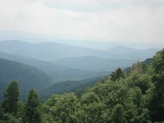
The geologic processes that led to the formation of the Appalachian Mountains started around 1.1 billion years ago with the creation of supercontinent Rodinia, and many Precambrian rocks and minerals created via this process remain visible today in the range's outcrops. The modern Appalachians and their relatives themselves were created by a series of three distinct orogenies beginning approximately 480 million years ago, making them one of the oldest surviving mountain ranges in the world.
The young Appalachians reached elevations similar to today's Alps and Rockies—both of which are significantly younger mountain ranges—before 240 million years of natural erosion by water, wind, ice, and gravity gradually morphed them into the lower, rugged peaks typically seen today.
Considering their extensive length, the Appalachians contain a diverse selection of biomes ranging from the temperate broadleaf and mixed Appalachian-Blue Ridge forest in the south to the boreal Eastern Canadian forest in the north. Conifers like red spruce and balsam fir dominate the north and high elevations, while deciduous trees like sugar maple and beech are more prevalent further south and oak-chestnut forests reign between.
The climate ranges from humid subtropical to subarctic, with a few peaks in the Presidential Range of New Hampshire's White Mountains having a true tundra climate; many locations are also oceanic or humid continental. Mammals like black bear, white-tailed deer, squirrels, raccoons, and skunks are common throughout the range, while others like moose are more regionally limited.
Birds, fish, shellfish, amphibians like salamanders, and other invertebrates are also abound in the profoundly ecologically diverse region. Once-largely extirpated species like the bobcat and coyote have also made a resurgence in recent years.
The Appalachian Mountains are a barrier to east–west travel, as they form a series of alternating ridgelines and valleys oriented in opposition to most highways and railroads running east–west. This barrier was extremely important in shaping the expansion of the United States in the colonial era. Much of the range's economy was historically based on logging and coal mining, which attracted many migrants who contributed to the genesis of a new cultural region.
Though the decline of these industries was an economic detriment, many communities have pivoted to manufacturing and services. Tourism has also become increasingly prevalent: the mountains are home to the very popular Appalachian Trail, a 2,175-mile (3,500 km) hiking trail that runs from Mount Katahdin in Maine to Springer Mountain in Georgia.
The International Appalachian Trail is an extension of this hiking trail into the Canadian portion of the Appalachian range in New Brunswick and Quebec.
Etymology
While exploring inland along the northern coast of Florida in 1528, the members of the Narváez expedition, including Álvar Núñez Cabeza de Vaca, found a Native American village near present-day Tallahassee, Florida, the name of which they transcribed as Apalchen or Apalachen (Apalachee pronunciation: [a.paˈla.tʃɛn]).
The name was soon altered by the Spanish to Apalachee and used as a name for the tribe and region spreading well inland to the north. Pánfilo de Narváez's expedition first entered Apalachee territory on June 15, 1528, and applied the name. Now spelled "Appalachian", it is the fourth-oldest surviving European place-name in the US.
After the 1540 expedition of Hernando de Soto, Spanish cartographers began to apply the name of the tribe to the mountains themselves. The first cartographic appearance of Apalchen is on Diego Gutiérrez's map of 1562; the first use for the mountain range is the map of Jacques le Moyne de Morgues in 1565.
The name was not commonly used for the whole mountain range until the late 19th century. A competing and often more popular name was the "Allegheny Mountains", "Alleghenies", and even "Alleghania". In the early 19th century, Washington Irving proposed renaming the United States either Appalachia or Alleghania.
In U.S. dialects in most regions of the Appalachians, the word is pronounced /ˌæpəˈlætʃɪnz/, with the third syllable sounding like "latch".
In some northern parts of the mountain range, particularly Pennsylvania, it is pronounced /ˌæpəˈleɪtʃɪnz/ or /ˌæpəˈleɪʃɪnz/; the third syllable is like "lay", and the fourth "chins" or "shins".
There is often great debate between the residents of the regions regarding the correct pronunciation. Elsewhere, a commonly accepted pronunciation for the adjective Appalachian is /ˌæpəˈlætʃiən/, with the last two syllables "-ian" pronounced as in the word "Romanian".
Geography
Perhaps partly because the range runs through large portions of both the United States and Canada, and partly because the range was formed over numerous geologic time periods, one of which is sometimes termed the Appalachian orogeny, writing communities struggle to agree on an encyclopedic definition of the mountain range.
However, each of the governments has an agency that informs the public about the major landforms that make up the countries, the United States Geological Survey (USGS) and the Geological Survey of Canada (GSC). The landforms are referred to as physiographic regions. The regions create precise boundaries from which maps can be drawn.
The Appalachian Highlands is the name of one of the eight physiographic regions of the contiguous 48 United States. The Appalachian Uplands is the name of one of seven physiographic regions of Canada.
Appalachian Highlands of the United States
The second level in the physiographic classification schema for the USGS is "province", the same word as Canada uses to divide its political subdivisions, meaning that the terminology used by the two countries do not match below the region level. The lowest level of classification is "section".
- Piedmont, including the Uplands and Lowlands sections
- Blue Ridge, including the Northern and Southern sections
- Valley and Ridge, including Tennessee, Middle, and Hudson Valley sections
- St. Lawrence Valley, including only the Champlain section
- Appalachian Plateaus, including the Mohawk, Catskill, Southern New York, Allegheny Mountains, Kanawha, Cumberland Plateau, and Cumberland Mountain sections
- New England, including the Seaboard Lowland, New England Upland, White Mountains, Green Mountains, and Taconic Mountains
- Adirondack with no sections
Appalachian Uplands of Canada
The Appalachian Uplands are one of the seven physiographic divisions in Canada. Canada's GSC does not use the same classification system as the USGS below the division level. The agency does break the divisions of the Appalachian Uplands into 13 subsections that are in four different political provinces of Canada.
- Newfoundland contains the Newfoundland Highlands, Atlantic Uplands, and Central Lowlands.
- Nova Scotia contains the Atlantic Uplands, Nova Scotia Uplands, and the Annapolis Lowlands
- New Brunswick contains the New Brunswick Highlands, the Chaleur Uplands, and the Maritime Plain
- Quebec contains the Notre Dame Mountains, Eastern Quebec Uplands, Sutton Mountains, and Mégantic Hills
While the Appalachian Highlands and Appalachian Uplands are generally continuous across the U.S./Canadian border, the St. Lawrence Valley area is handled differently in the physiographic classification schemas. The part of the St. Lawrence Valley in the United States is one of the second-level classifications, part of the Appalachian Highlands.
In Canada, the area is part of the first-level classification, the St. Lawrence Lowlands. This includes the area around the city of Montreal, Anticosti Island, and the northwest coastline of Newfoundland. The dissected plateau area, while not actually made up of geological mountains, is popularly called "mountains", especially in eastern Kentucky and West Virginia, and while the ridges are not high, the terrain is extremely rugged.
In Ohio and New York, some of the plateau has been glaciated, which has rounded off the sharp ridges and filled the valleys to some extent. The glaciated regions are usually referred to as hill country rather than mountains.
Range characteristics
The Appalachian belt includes the plateaus sloping southward to the Atlantic Ocean in New England, and southeastward to the border of the coastal plain through the central and southern Atlantic states; and on the northwest, the Allegheny and Cumberland plateaus declining toward the Great Lakes and the interior plains.
A remarkable feature of the belt is the longitudinal chain of broad valleys, including the Great Appalachian Valley, which in the southerly sections divides the mountain system into two unequal portions, but in the northernmost lies west of all the ranges possessing typical Appalachian features, and separates them from the Adirondack group.
The mountain system has no axis of dominating altitudes, but in every portion, the summits rise to rather uniform heights, and, especially in the central section, the various ridges and intermontane valleys have the same trend as the system itself. None of the summits reaches the region of perpetual snow.
In Pennsylvania, there are over sixty summits that rise over 2,500 ft (800 m); the summits of Mount Davis and Blue Knob rise over 3,000 ft (900 m). In Maryland, Eagle Rock and Dans Mountain are conspicuous points reaching 3,162 and 2,882 ft (964 and 878 m) respectively. On the same side of the Great Valley, south of the Potomac, are the Pinnacle 3,007 feet (917 m) and Pigeon Roost 3,400 ft (1,000 m).
In West Virginia, more than 150 peaks rise above 4,000 ft (1,200 m), including Spruce Knob 4,863 ft (1,482 m), the highest point in the Allegheny Mountains. A number of other points in the state rise above 4,800 ft (1,500 m). Cheat Mountain (Snowshoe Mountain) at Thorny Flat 4,848 ft (1,478 m) and Bald Knob 4,842 ft (1,476 m) are among the more notable peaks in West Virginia.
The Blue Ridge Mountains, rising in southern Pennsylvania and there known as South Mountain, attain elevations of about 2,000 ft (600 m) in Pennsylvania. South Mountain achieves its highest point just below the Mason-Dixon line in Maryland at Quirauk Mountain 2,145 ft (654 m) and then diminishes in height southward to the Potomac River.
Once in Virginia, the Blue Ridge again reaches 2,000 ft (600 m) and higher. In the Virginia Blue Ridge, the following are some of the highest peaks north of the Roanoke River: Stony Man 4,031 ft (1,229 m), Hawksbill Mountain 4,066 ft (1,239 m), Apple Orchard Mountain 4,225 ft (1,288 m) and Peaks of Otter 4,001 and 3,875 ft (1,220 and 1,181 m).
South of the Roanoke River, along the Blue Ridge, are Virginia's highest peaks including Whitetop Mountain 5,520 ft (1,680 m) and Mount Rogers 5,729 ft (1,746 m), the highest point in the Commonwealth.
Chief summits in the southern section of the Blue Ridge are located along two main crests, the Western or Unaka Front along the Tennessee-North Carolina border and the Eastern Front in North Carolina, or one of several "cross ridges" between the two main crests. Major subranges of the Eastern Front include the Black Mountains, Great Craggy Mountains, and Great Balsam Mountains, and its chief summits include Grandfather Mountain 5,964 ft (1,818 m) near the Tennessee-North Carolina border, Mount Mitchell 6,684 ft (2,037 m) in the Blacks, and Black Balsam Knob 6,214 ft (1,894 m) and Cold Mountain 6,030 ft (1,840 m) in the Great Balsams.
The Western Blue Ridge Front is subdivided into the Unaka Range, the Bald Mountains, the Great Smoky Mountains, and the Unicoi Mountains, and its major peaks include Roan Mountain 6,285 ft (1,916 m) in the Unakas, Big Bald 5,516 ft (1,681 m) and Max Patch 4,616 ft (1,407 m) in the Bald Mountains, Kuwohi 6,643 ft (2,025 m), Mount Le Conte 6,593 feet (2,010 m), and Mount Guyot 6,621 ft (2,018 m) in the Great Smokies, and Big Frog Mountain 4,224 ft (1,287 m) near the Tennessee-Georgia-North Carolina border.
Prominent summits in the cross ridges include Waterrock Knob (6,292 ft (1,918 m)) in the Plott Balsams. Across northern Georgia, numerous peaks exceed 4,000 ft (1,200 m), including Brasstown Bald, the state's highest, at 4,784-and-4,696 ft (1,458-and-1,431 m) Rabun Bald. In north-central Alabama, Mount Cheaha rises prominently to 1,445 feet (440 m) over its surroundings, as part of the southernmost spur of the Blue Ridge Mountains.
- Alabama — US — Appalachian Plateau — Cheaha Mountain — 2,407 — 734 — 33.4869° N 85.8091° W
- Connecticut — US — New England — Bear Mountain — 2,316 — 706 — 42.0241° N 73.2716° W
- Georgia — US — Blue Ridge — Brasstown Bald — 4,784 — 1,457 — 34.8745° N 83.8063° W
- Kentucky — US — Appalachian Plateau — Black Mountain — 4,145 — 1,263 — 36.9022° N 82.9144° W
- Maine — US — New England — Mount Katahdin — 5,269 — 1,606 — 45.9046° N 68.9216° W
- Maryland — US — Appalachian Plateau — Backbone Mountain — 3,360 — 1,024 — 39.4049° N 79.2911° W
- Massachusetts — US — New England — Mount Greylock — 3,489 — 1,063 — 42.3813° N 73.0957° W
- New Brunswick — Canada — Chaleur Uplands — Mount Carleton — 2,690 — 820 — 47.2241° N 66.5233° W
- Newfoundland — Canada — Newfoundland — The Cabox — 2,664 — 812 — 48.4959° N 58.2903° W
- New Hampshire — US — New England — Mount Washington — 6,288 — 1,917 — 44.1614° N 71.1811° W
- New Jersey — US — Valley and Ridge — High Point — 1,804 — 550 — 41.3206° N 74.6616° W
- New York — US — Adirondacks — Mount Marcy — 5,344 — 1,629 — 44.1126° N 73.9235° W
- North Carolina — US — Blue Ridge — Mount Mitchell — 6,684 — 2,037 — 35.7658° N 82.2655° W
- Nova Scotia — Canada — Nova Scotia Highlands — White Hill — 1,755 — 535 — 46.7555° N 60.6350° W
- Ohio — US — Appalachian Plateau — Campbell Hill — 1,549 — 472 — 40.3888° N 83.6381° W
- Pennsylvania — US — Appalachian Plateau — Mount Davis — 3,213 — 979 — 39.7866° N 79.1751° W
- Quebec — Canada — Notre Dame Mountains — Mont Jacques-Cartier — 4,160 — 1,268 — 48.9906° N 65.9425° W
- South Carolina — US — Blue Ridge — Sassafras Mountain — 3,553 — 1,083 — 35.0632° N 82.3062° W
- Tennessee — US — Blue Ridge — Kuwohi — 6,643 — 2,025 — 35.5625° N 83.4989° W
- Vermont — US — Green Mountains — Mount Mansfield — 4,395 — 1,340 — 44.5439° N 72.8143° W
- Virginia — US — Blue Ridge — Mount Rogers — 5,729 — 1,746 — 36.6586° N 81.5438° W
- West Virginia — US — Appalachian Plateau — Spruce Knob — 4,863 — 1,482 — 38.6992° N 79.5327° W
Categorization of Appalachian mountains before physiographic regions
Sources written prior to the recognition of the concept of physiographic regions divided the Appalachian Mountains into three major sections: