















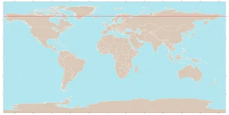
The Arctic Circle marks the southernmost latitude for which at the December solstice (winter) the Sun does not rise and at the June solstice (summer) the Sun does not set. These phenomena are referred to as polar night and midnight sun, respectively, and the closer to the pole one goes, the longer that situation persists.
For example, in the Russian port city of Murmansk (three degrees north of the Arctic Circle) the Sun stays below the horizon for 20 days before and after the winter solstice, and above the horizon for 20 days before and after the summer solstice.
The positions of the Arctic and Antarctic Circles vary slightly from year to year. Currently the Arctic Circle is 66°33′51.1″ north of the Equator. Its latitude depends on Earth's axial tilt, which fluctuates by a margin of some 2° over a 41,000-year period due to tidal forces resulting from the orbit of the Moon.
Consequently, in the current epoch the Arctic Circle is drifting toward the North Pole, while the Antarctic Circle drifts towards the South Pole, each at a speed of about 14.5 m (48 ft) per year.
Etymology
The word arctic comes from the Greek word ἀρκτικός (arktikos: "near the Bear, northern") and that from the word ἄρκτος (arktos: "bear").
Midnight sun and polar night
The Arctic Circle is the southernmost latitude in the Northern Hemisphere at which the centre of the Sun can remain continuously above or below the horizon for twenty-four hours; as a result, at least once each year at any location within the Arctic Circle the centre of the Sun is visible at local midnight, and at least once the centre is not visible at local noon.
Directly on the Arctic Circle these events occur, in principle, exactly once per year: at the June and December solstices, respectively. However, because of atmospheric refraction and mirages, and also because the sun appears as a disk and not a point, part of the midnight sun is visible, on the night of the northern summer solstice, at a latitude of about 50 minutes of arc (′) (90 km (56 mi)) south of the Arctic Circle.
Similarly, on the day of the northern winter solstice, part of the Sun may be seen up to about 50′ north of the Arctic Circle. That is true at sea level; those limits increase with elevation above sea level, although in mountainous regions there is often no direct view of the true horizon.
Human habitation
The largest communities north of the Arctic Circle are situated in Russia, Norway, and Sweden: Murmansk (population 295,374) and Norilsk (178,018) in Russia; Tromsø (75,638) in Norway, Vorkuta (58,133) in Russia, Bodø (52,357) and Harstad (24,703) in Norway; and Kiruna, Sweden (22,841). In Finland, the largest settlement in the immediate vicinity of the Arctic Circle is Rovaniemi (62,667), lying 6 km (4 mi) south of the line. Salekhard (51,186) in Russia is the only city in the world located directly on the Arctic Circle.
In contrast, the largest Danish community north of the Arctic Circle, Sisimiut (Greenland), has approximately 5,600 inhabitants. In the United States, Utqiagvik, Alaska (formerly known as Barrow) is the largest settlement north of the Arctic Circle with about 5,000 inhabitants. The largest such community in Canada is Inuvik in the Northwest Territories, with 3,137 inhabitants.
Exclusive economic zones
The Arctic region, defined as the area north of 66°33′ N latitude, comprises land, internal waters, territorial seas, and exclusive economic zones (EEZs). All land and non-international waters within this circle fall under the jurisdiction of eight states: Canada, the Kingdom of Denmark (via Greenland), Finland, Iceland, Norway, Russia, Sweden, and the United States.
Under international law, including the United Nations Convention on the Law of the Sea (UNCLOS), the North Pole and the surrounding high seas of the Arctic Ocean are not owned by any country. Sovereignty in the region is managed through established maritime zones, though the "Arctic Five" (Canada, Denmark, Norway, Russia, and the United States) maintain specific rights over their respective continental shelves and EEZs.
Geography
The Arctic Circle is roughly 16,000 km (9,900 mi) in circumference. The area north of the Circle is about 20,000,000 km2 (7,700,000 sq mi) and covers roughly 4% of Earth's surface.
The Arctic Circle passes through the Arctic Ocean, the Scandinavian Peninsula, North Asia, Northern America, and Greenland. The land within the Arctic Circle is divided among eight countries: Norway, Sweden, Finland, Russia, the United States (Alaska), Canada (Yukon, Northwest Territories, and Nunavut), Denmark (Greenland), and Iceland (where it passes through the small offshore island of Grímsey).
Climate
The climate north of the Arctic Circle is generally cold, but the coastal areas of Norway have a generally mild climate as a result of the Gulf Stream, which makes the ports of northern Norway and northwest Russia ice-free all year long. In the interior, summers can be quite warm, while winters are extremely cold. For example, summer temperatures in Norilsk, Russia will sometimes reach as high as 30 °C (86 °F), while the winter temperatures frequently fall below −50 °C (−58 °F).
Sites along the Arctic Circle
Starting at the prime meridian and heading eastwards, the Arctic Circle passes through:
- 66°34′N 0°0′E / 66.567°N 0.000°E / 66.567; 0.000 (Prime Meridian) — Norwegian Sea
- 66°34′N 12°3′E / 66.567°N 12.050°E / 66.567; 12.050 (Nordland County, Norway) — Norway — Islands and skerries of Træna Municipality, Nordland County
- 66°34′N 12°18′E / 66.567°N 12.300°E / 66.567; 12.300 (Norwegian Sea) — Trænfjorden [no], Norwegian Sea
- 66°34′N 12°29′E / 66.567°N 12.483°E / 66.567; 12.483 (Nordland County, Norway) — Norway — Islands and skerries of Nesøya, Nordland County
- 66°34′N 12°41′E / 66.567°N 12.683°E / 66.567; 12.683 (Norwegian Sea) — Nesøyfjorden [no], Norwegian Sea
- 66°34′N 12°49′E / 66.567°N 12.817°E / 66.567; 12.817 (Nordland County, Norway) — Norway — Islands and skerries of Storselsøya, Nordland County
- 66°34′N 12°52′E / 66.567°N 12.867°E / 66.567; 12.867 (Norwegian Sea) — Kvarøyfjorden [no], Norwegian Sea
- 66°34′N 12°57′E / 66.567°N 12.950°E / 66.567; 12.950 (Nordland County, Norway) — Norway — Islands and skerries of Rangsundøya, Nordland County, including Vikingen island
- 66°34′N 13°3′E / 66.567°N 13.050°E / 66.567; 13.050 (Norwegian Sea) — Værangfjorden [no], Norwegian Sea
- 66°34′N 13°12′E / 66.567°N 13.200°E / 66.567; 13.200 (Nordland County, Norway) — Norway — Nordland County
- 66°34′N 15°33′E / 66.567°N 15.550°E / 66.567; 15.550 (Norrbotten County, Sweden) — Sweden — Norrbotten County (Provinces of Lapland and Norrbotten)
- 66°34′N 25°50′E / 66.567°N 25.833°E / 66.567; 25.833 (Lapland Province, Finland) — Finland — Lapland Region, crosses Rovaniemi Airport
- 66°34′N 29°28′E / 66.567°N 29.467°E / 66.567; 29.467 (Karelia, Russia) — Russia — Republic of Karelia
- 66°34′N 31°36′E / 66.567°N 31.600°E / 66.567; 31.600 (Murmansk, Russia) — Russia — Murmansk Oblast
- 66°34′N 32°37′E / 66.567°N 32.617°E / 66.567; 32.617 (Karelia, Russia) — Russia — Republic of Karelia
- 66°34′N 33°10′E / 66.567°N 33.167°E / 66.567; 33.167 (Murmansk, Russia) — Russia — Grand Island, Murmansk Oblast
- 66°34′N 33°25′E / 66.567°N 33.417°E / 66.567; 33.417 (Kandalaksha Gulf, White Sea) — Kandalaksha Gulf, White Sea, Barents Sea
- 66°34′N 34°28′E / 66.567°N 34.467°E / 66.567; 34.467 (Murmansk Oblast, Russia) — Russia — Kola Peninsula, Murmansk Oblast — for about 7 km (4.3 mi)
- 66°34′N 34°38′E / 66.567°N 34.633°E / 66.567; 34.633 (Kandalaksha Gulf, White Sea) — Kandalaksha Gulf, White Sea, Barents Sea
- 66°34′N 35°0′E / 66.567°N 35.000°E / 66.567; 35.000 (Murmansk Oblast, Kola Peninsula, Russia) — Russia — Kola Peninsula, Murmansk Oblast
- 66°34′N 40°42′E / 66.567°N 40.700°E / 66.567; 40.700 (White Sea) — White Sea, Barents Sea
- 66°34′N 44°23′E / 66.567°N 44.383°E / 66.567; 44.383 (Nenets Autonomous Okrug, Russia) — Russia — Nenets Autonomous Okrug
- 66°34′N 50°51′E / 66.567°N 50.850°E / 66.567; 50.850 (Komi Republic, Russia) — Russia — Komi Republic
- 66°34′N 63°48′E / 66.567°N 63.800°E / 66.567; 63.800 (Yamalo-Nenets Autonomous Okrug, Russia) — Russia — Yamalo-Nenets Autonomous Okrug
- 66°34′N 71°5′E / 66.567°N 71.083°E / 66.567; 71.083 (Gulf of Ob) — Gulf of Ob, Kara Sea
- 66°34′N 72°27′E / 66.567°N 72.450°E / 66.567; 72.450 (Yamalo-Nenets Autonomous Okrug, Russia) — Russia — Yamalo-Nenets Autonomous Okrug
- 66°34′N 83°3′E / 66.567°N 83.050°E / 66.567; 83.050 (Krasnoyarsk Krai, Russia) — Russia — Krasnoyarsk Krai
- 66°34′N 106°18′E / 66.567°N 106.300°E / 66.567; 106.300 (Sakha Republic, Russia) — Russia — Yukaghir Highlands, Sakha Republic
- 66°34′N 158°38′E / 66.567°N 158.633°E / 66.567; 158.633 (Chukotka Autonomous Okrug, Russia) — Russia — Anadyr Highlands and Chukotka Mountains, Chukotka Autonomous Okrug
- 66°34′N 171°1′W / 66.567°N 171.017°W / 66.567; -171.017 (Chukchi Sea, Arctic Ocean) — Chukchi Sea
- 66°34′N 164°38′W / 66.567°N 164.633°W / 66.567; -164.633 (Seward Peninsula, Alaska, United States) — United States — Seward Peninsula, Alaska
- 66°34′N 163°44′W / 66.567°N 163.733°W / 66.567; -163.733 (Kotzebue Sound, Arctic Ocean) — Kotzebue Sound, Chukchi Sea
- 66°34′N 161°56′W / 66.567°N 161.933°W / 66.567; -161.933 (Alaska, United States) — United States — Alaska—passing through Selawik Lake
- 66°34′N 141°0′W / 66.567°N 141.000°W / 66.567; -141.000 (Yukon, Canada) — Canada — Yukon
- 66°34′N 133°36′W / 66.567°N 133.600°W / 66.567; -133.600 (Northwest Territories, Canada) — Canada — Northwest Territories, passing through Great Bear Lake
- 66°34′N 115°56′W / 66.567°N 115.933°W / 66.567; -115.933 (Nunavut, Canada) — Canada — Nunavut
- 66°34′N 82°59′W / 66.567°N 82.983°W / 66.567; -82.983 (Foxe Basin, Hudson Bay) — Foxe Basin
- 66°34′N 73°25′W / 66.567°N 73.417°W / 66.567; -73.417 (Baffin Island, Nunavut, Canada) — Canada — Nunavut (Baffin Island), passing through Nettilling Lake and Auyuittuq National Park (sign location)
- 66°34′N 61°24′W / 66.567°N 61.400°W / 66.567; -61.400 (Davis Strait, Atlantic Ocean) — Davis Strait
- 66°34′N 53°16′W / 66.567°N 53.267°W / 66.567; -53.267 (Greenland) — Greenland — Passing through Kangerlussuaq Fjord and Schweizerland
- 66°34′N 34°9′W / 66.567°N 34.150°W / 66.567; -34.150 (Denmark Strait, Atlantic Ocean) — Denmark Strait
- 66°34′N 26°18′W / 66.567°N 26.300°W / 66.567; -26.300 (Greenland Sea) — Atlantic Ocean — Greenland Sea
- 66°34′N 18°1′W / 66.567°N 18.017°W / 66.567; -18.017 (Grímsey, Iceland) — Iceland — Island of Grímsey
- 66°34′N 17°59′W / 66.567°N 17.983°W / 66.567; -17.983 (Greenland Sea, Atlantic Ocean) — Greenland Sea
- 66°34′N 12°32′W / 66.567°N 12.533°W / 66.567; -12.533 (Norwegian Sea) — Atlantic Ocean — Norwegian Sea