














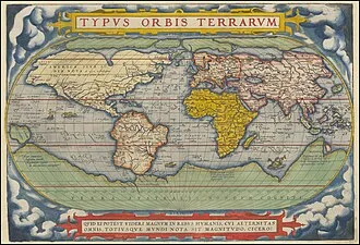
The history of geography as a discipline spans cultures and millennia, having been independently developed by multiple groups and cross-pollinated through trade between them. Geography as a discipline dates back to the earliest attempts to understand the world spatially, with the earliest example of an attempted world map dating to the 9th century BC in ancient Babylon.
Origins of many of the concepts in geography can be traced to Greek Eratosthenes of Cyrene, who may have coined the term "geographia" (c. 276 BC – c. 195/194 BC). The first recorded use of the word γεωγραφία was as the title of a book by Greek scholar Claudius Ptolemy (100 – 170 AD).
During the Middle Ages, geography was influenced by Islamic scholars, such as Muhammad al-Idrisi, producing detailed maps of the world. The Age of Discovery was influential in the development of geography, as European explorers mapped the New World. Modern developments include geomatics and geographic information science.
The core concepts of geography that are consistent across all approaches are space, place, time, and scale. Today, geography is an extremely broad discipline with multiple approaches and modalities. The main branches of geography are physical geography, human geography, and technical geography. Physical geography focuses on the natural environment, human geography on how humans interact with the Earth, and technical geography on developing tools for understanding geography.
Techniques employed can generally be broken down into quantitative and qualitative approaches, with many studies taking mixed-methods approaches. Common techniques include cartography, remote sensing, interviews, and surveying.
Fundamentals
Geography is a systematic study of the Earth (other celestial bodies are specified, such as "geography of Mars", or given another name, such as areography in the case of Mars, or selenography in the case of the Moon, or planetography for the general case), its features, and phenomena that take place on it. For something to fall into the domain of geography, it generally needs some spatial component that can be placed on a map, such as coordinates, place names, or addresses.
This has led to geography being associated with cartography and place names. Although many geographers are trained in toponymy and cartology, this is not their main preoccupation. Geographers study the Earth's spatial and temporal distribution of phenomena, processes, and features as well as the interaction of humans and their environment.
Because space and place affect a variety of topics, such as economics, health, climate, plants, and animals, geography is highly interdisciplinary. The interdisciplinary nature of the geographical approach depends on attentiveness to the relationships among physical and human phenomena and their spatial patterns.
While narrowing down geography to a few key concepts is extremely challenging and subject to tremendous debate within the discipline, several sources have approached the topic. The 1st edition of the book "Key Concepts in Geography" broke down this into chapters focusing on "Space," "Place," "Time," "Scale," and "Landscape." The 2nd edition of the book expanded on these key concepts by adding "Environmental systems," "Social Systems," "Nature," "Globalization," "Development," and "Risk," demonstrating how challenging narrowing the field can be.
Another approach used extensively in teaching geography is the Five themes of geography established by "Guidelines for Geographic Education: Elementary and Secondary Schools," published jointly by the National Council for Geographic Education and the Association of American Geographers in 1984. These themes are Location, place, relationships within places (often summarized as Human-Environment Interaction), movement, and regions. The five themes of geography have shaped how American education approaches the topic in the years since.
Space
Just as all phenomena exist in time and thus have a history, they also exist in space and have a geography.
— United States National Research Council, 1997
For something to exist in the realm of geography, it must be able to be described spatially. Thus, space is the most fundamental concept at the foundation of geography. The concept is so basic, that geographers often have difficulty defining exactly what it is. Absolute space is the exact site, or spatial coordinates, of objects, persons, places, or phenomena under investigation.
We exist in space. Absolute space leads to the view of the world as a photograph, with everything frozen in place when the coordinates were recorded. Today, geographers are trained to recognize the world as a dynamic space where all processes interact, rather than as a static image on a map.
Place
Place is one of the most complex and important terms in geography. In human geography, place is the synthesis of the coordinates on the Earth's surface, the activity and use that occurs, has occurred, and will occur at the coordinates, and the meaning ascribed to the space by human individuals and groups. This can be extraordinarily complex, as different spaces may have different uses at different times and mean different things to different people.
In physical geography, a place encompasses all the physical phenomena occurring in space, including the lithosphere, atmosphere, hydrosphere, and biosphere. Places do not exist in a vacuum and instead have complex spatial relationships with each other, and place is concerned how a location is situated in relation to all other locations.
As a discipline then, the term place in geography includes all spatial phenomena occurring at a location, the diverse uses and meanings humans ascribe to that location, and how that location impacts and is impacted by all other locations on Earth. In one of Yi-Fu Tuan's papers, he explains that in his view, geography is the study of Earth as a home for humanity, and thus place and the complex meaning behind the term are central to the discipline of geography.
Time
Time is usually considered within the domain of history; however, it is a significant concern in geography. In physics, space and time are not separated, and are combined into the concept of spacetime.
Geography is subject to the laws of physics, and when studying phenomena in space, time must be taken into account. Time in geography is more than just the historical record of events at discrete coordinates; it also includes modeling the dynamic movement of people, organisms, and things through space. Time facilitates movement through space, ultimately allowing things to flow through a system.
The amount of time an individual, or group of people, spends in a place will often shape their attachment and perspective to that place. Time constrains the possible paths that can be taken through space, given a starting point, possible routes, and rate of travel. Visualizing time over space is challenging in terms of cartography, and includes Space-Prism, advanced 3D geovisualizations, and animated maps.
Scale
Scale in the context of a map is the ratio between a distance measured on the map and the corresponding distance as measured on the ground. This concept is fundamental to the discipline of geography, not just cartography, in that phenomena being investigated appear different depending on the scale used. Scale is the frame that geographers use to measure space, and ultimately to understand a place.
Laws of geography
During the quantitative revolution, geography shifted to an empirical law-making (nomothetic) approach. Several laws of geography have been proposed since then, most notably by Waldo Tobler and can be viewed as a product of the quantitative revolution. In general, some dispute the entire concept of laws in geography and the social sciences.
These criticisms have been addressed by Tobler and others, such as Michael Frank Goodchild. However, this is an ongoing source of debate in geography and is unlikely to be resolved anytime soon. Several laws have been proposed, and Tobler's first law of geography is the most generally accepted in geography. Some have argued that geographic laws do not need to be numbered.
The existence of a first invites a second, and many have proposed themselves as that. It has also been proposed that Tobler's first law of geography should be moved to the second and replaced with another. A few of the proposed laws of geography are below:
- Tobler's first law of geography: "Everything is related to everything else, but near things are more related than distant."
- Tobler's second law of geography: "The phenomenon external to a geographic area of interest affects what goes on inside."
- Arbia's law of geography: "Everything is related to everything else, but things observed at a coarse spatial resolution are more related than things observed at a finer resolution."
- Spatial heterogeneity: Geographic variables exhibit uncontrolled variance.
- The uncertainty principle: "That the geographic world is infinitely complex and that any representation must therefore contain elements of uncertainty, that many definitions used in acquiring geographic data contain elements of vagueness, and that it is impossible to measure location on the Earth's surface exactly."
Additionally, several variations or amendments to these laws have been proposed in the literature, though they are less well supported. For example, one paper proposed an amended version of Tobler's first law of geography, referred to in the text as the Tobler–von Thünen law, which states: "Everything is related to everything else, but near things are more related than distant things, as a consequence of accessibility."
Sub-disciplines
Geography is a branch of inquiry that focuses on spatial information on Earth. It is an extremely broad topic and can be broken down in multiple ways. There have been several approaches to doing this spanning at least several centuries, including "four traditions of geography" and into distinct branches. The Four traditions of geography are often used to divide the different historical approach theories geographers have taken to the discipline. In contrast, geography's branches describe contemporary applied geographical approaches.
Four traditions
Geography is an extremely broad field. Because of this, many view the various definitions of geography proposed over the decades as inadequate. To address this, William D. Pattison proposed the concept of the "Four traditions of Geography" in 1964. These traditions are the Spatial or Locational Tradition, the Man-Land or Human-Environment Interaction Tradition (sometimes referred to as Integrated geography), the Area Studies or Regional Tradition, and the Earth Science Tradition.
These concepts are broad sets of geography philosophies bound together within the discipline. They are one of many ways in which geographers organize the major sets of thought and philosophy within the discipline.
Branches
In another approach to the abovementioned four traditions, geography is organized into applied branches. The UNESCO Encyclopedia of Life Support Systems organizes geography into the three categories of human geography, physical geography, and technical geography. Some publications limit the number of branches to physical and human, describing them as the principal branches.
Human geography largely focuses on the built environment and how humans create, view, manage, and influence space. Physical geography examines the natural environment and how organisms, climate, soil, water, and landforms produce and interact, studying spatial patterns in the natural environment, atmosphere, hydrosphere, biosphere, and geosphere.
The difference between these approaches led to the development of integrated geography, which combines physical and human geography and concerns the interactions between the environment and humans. Technical geography involves studying and developing the tools and techniques used by geographers, such as remote sensing, cartography, and geographic information system.
It is the newest of the branches, and often other terms are used in the literature to describe the emerging category. While human and physical geographers use the techniques employed by technical geographers, technical geography is more concerned with the fundamental spatial concepts and technologies than with the nature of the data.
It is therefore closely associated with the spatial tradition of geography while being applied to the other two major branches. These branches use similar geographic philosophies, concepts, and tools, and often overlap significantly, so geographers rarely focus on just one topic; they often use one as their primary focus and then incorporate data and methods from the other branches.
Often, geographers are asked to describe what they do by individuals outside the discipline and are likely to identify closely with a specific branch, or sub-branch, when describing themselves to lay people.
Physical
Physical geography (or physiography) focuses on geography as an Earth science. It aims to understand the physical problems and the issues of lithosphere, hydrosphere, atmosphere, pedosphere, and global flora and fauna patterns (biosphere). Physical geography is the study of earth's seasons, climate, atmosphere, soil, streams, landforms, and oceans. Physical geographers will often work in identifying and monitoring the use of natural resources.
Human
Human geography (or anthropogeography) is a branch of geography that studies the patterns and processes that shape human society. It encompasses the human, political, cultural, social, and economic aspects. In industry, human geographers often work in city planning, public health, or business analysis. Various approaches to the study of human geography have also arisen through time and include behavioral geography, culture theory, feminist geography, and geosophy.
Human geographers study people and their communities, cultures, economies, and environmental interactions by studying their relations with and across space and place.
Technical
Technical geography involves studying and developing tools, techniques, and statistical methods for collecting, analysing, using, and understanding spatial data. Technical geography is the most recently recognized, and controversial, of the branches. Its use dates back to 1749, when a book published by Edward Cave organized the discipline into a section containing content such as cartographic techniques and globes.
There are several other terms, often used interchangeably with technical geography to subdivide the discipline, including "techniques of geographic analysis," "Geographic Information Technology," "Geography method's and techniques," "Geographic Information Science," "geoinformatics," "geomatics," and "information geography".
There are subtle differences between each concept and term; however, technical geography is one of the broadest, consistent with the naming convention of the other two branches, has been in use since the 1700s, and has been used by the UNESCO Encyclopedia of Life Support Systems to divide geography into themes. As academic fields increasingly specialize in their nature, technical geography has emerged as a branch of geography specializing in geographic methods and thought.
The emergence of technical geography has brought new relevance to the broad discipline of geography by serving as a set of unique methods for managing the interdisciplinary nature of the phenomena under investigation. A technical geographer might work as a GIS analyst, a GIS developer creating new software tools, or a cartographer creating general reference maps incorporating human and natural features.
Methods
All geographic research and analysis start with asking the question "where," followed by "why there." Geographers start with the fundamental assumption outlined in Tobler's first law of geography, that "everything is related to everything else, but near things are more related than distant things." As spatial interrelationships are key to this synoptic science, maps are a key tool. Classical cartography has been joined by a more modern approach to geographical analysis, computer-based geographic information systems (GIS).
In their study, geographers use four interrelated approaches:
- Analytical – Asks why we find features and populations in a specific geographic area.
- Descriptive – Specifies the locations of features and populations.
- Regional – Examines systematic relationships between categories for a specific region or location on the planet.
- Systematic – Groups geographical knowledge into categories that can be explored globally.
Quantitative methods
Quantitative methods in geography became particularly influential in the discipline during the quantitative revolution of the 1950s and 60s. These methods revitalized the discipline in many ways, allowing scientific testing of hypotheses and proposing scientific geographic theories and laws. The quantitative revolution heavily influenced and revitalized technical geography, and lead to the development of the subfield of quantitative geography.
Quantitative cartography
Cartography is the art, science, and technology of making maps. Cartographers study the Earth's surface representation with abstract symbols (map making). Although other subdisciplines of geography rely on maps to present their analyses, the actual making of maps is sufficiently abstract to be regarded as a separate activity. Cartography has grown from a collection of drafting techniques into an actual science.
Cartographers must learn cognitive psychology and ergonomics to understand which symbols convey information about the Earth most effectively, and behavioural psychology to induce readers of their maps to act on that information. They must learn geodesy and fairly advanced mathematics to understand how the shape of the Earth affects the distortion of map symbols projected onto a flat surface for viewing.
It can be said, without much controversy, that cartography is the seed from which the larger field of geography grew.
Geographic information systems
Geographic information systems (GIS) store information about the Earth for accurate, automated retrieval by a computer, appropriate to the information's purpose. In addition to all of the other subdisciplines of geography, GIS specialists must understand computer science and database systems. GIS has revolutionized the field of cartography: nearly all mapmaking is now done with the assistance of some form of GIS software.
The science of using GIS software and GIS techniques to represent, analyse, and predict the spatial relationships is called geographic information science (GISc).
Remote sensing
Remote sensing is the art, science, and technology of obtaining information about Earth's features from measurements made at a distance. Remotely sensed data can be either passive, such as traditional photography, or active, such as LiDAR. A variety of platforms can be used for remote sensing, including satellite imagery, aerial photography (including consumer drones), and data obtained from hand-held sensors.
Products from remote sensing include Digital elevation model and cartographic base maps. Geographers increasingly use remotely sensed data to obtain information about the Earth's land surface, ocean, and atmosphere, because it: (a) supplies objective information at a variety of spatial scales (local to global), (b) provides a synoptic view of the area of interest, (c) allows access to distant and inaccessible sites, (d) provides spectral information outside the visible portion of the electromagnetic spectrum, and (e) facilitates studies of how features/areas change over time.
Remotely sensed data may be analyzed independently or in conjunction with other digital data layers (e.g., in a geographic information system). Remote sensing aids in land use and land cover (LULC) mapping by helping determine what is naturally occurring on a piece of land and what human activities are taking place there.
Geostatistics
Geostatistics deals with quantitative data analysis, specifically the application of a statistical methodology to the exploration of geographic phenomena. Geostatistics is used extensively in a variety of fields, including hydrology, geology, petroleum exploration, weather analysis, urban planning, logistics, and epidemiology.
The mathematical basis for geostatistics derives from cluster analysis, linear discriminant analysis, and non-parametric statistical tests, and a variety of other subjects. Applications of geostatistics rely heavily on geographic information systems, particularly for the interpolation (estimate) of unmeasured points. Geographers are making notable contributions to quantitative methods.
Qualitative methods
Qualitative methods in geography are descriptive rather than numerical or statistical in nature. They add context to concepts, and explore human concepts like beliefs and perspective that are difficult or impossible to quantify. Human geography is much more likely to employ qualitative methods than physical geography. Increasingly, technical geographers are attempting to employ GIS methods on qualitative datasets.
Qualitative cartography
Qualitative cartography employs many of the same software and techniques as quantitative cartography. It may be employed to inform on map practices, or to visualize perspectives and ideas that are not strictly quantitative in nature. An example of a form of qualitative cartography is a Chorochromatic map of nominal data, such as land cover or dominant language group in an area.
Another example is a deep map, or maps that combine geography and storytelling to produce a product with greater information than a two-dimensional image of places, names, and topography. This approach offers more inclusive strategies than more traditional cartographic approaches for connecting the complex layers that makeup places.
Ethnography
Human geographers use ethnographic research techniques. In cultural geography, there is a tradition of employing qualitative research techniques, also used in anthropology and sociology. Participant observation and in-depth interviews provide human geographers with qualitative data.
Geopoetics
Geopoetics is an interdisciplinary approach that combines geography and poetry to explore the interconnectedness between humans, space, place, and the environment. Geopoetics is employed as a mixed methods tool to explain the implications of geographic research. It is often employed to address and communicate the implications of complex topics, such as the anthropocene.
Interviews
Geographers employ interviews to gather data and acquire valuable understandings from individuals or groups regarding their encounters, outlooks, and opinions concerning spatial phenomena. Interviews can be carried out through various mediums, including face-to-face interactions, phone conversations, online platforms, or written exchanges.
Geographers typically adopt a structured or semi-structured approach during interviews involving specific questions or discussion points when utilized for research purposes. These questions are designed to extract focused information about the research topic while being flexible enough to allow participants to express their experiences and viewpoints, such as through open-ended questions.