














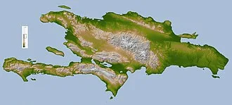
Hispaniola is the site of the first European fort in the Americas, La Navidad (1492–1493), the first settlement, La Isabela (1493–1500), and the first permanent settlement, the capital of the Dominican Republic, Santo Domingo (1498–present). These settlements were founded successively during each of Columbus's first three voyages under the patronage of the Spanish Empire.
The Spanish controlled the island from 1492 until the 17th century, when French pirates began establishing bases on the western side of the island, which resulted in the creation of the Saint-Domingue colony under the French Empire by 1659. The most commonly used name for the island is Española ("diminutive for Spain, according to Pedro Mártir de Anglería"), whose Latinized form is Hispaniola.
The name of Santo Domingo, after Saint Dominic de Guzmán, the Castilian Catholic priest founder of the Dominican Order, is also widely used.
Etymology
Indigenous rule
At the time of its European discovery during the first voyage of Christopher Columbus in 1492, the island was called various names by its Native peoples: the Ciguayo, the Macorix, and the Taíno. Early chroniclers identified the Indigenous names (appearing with various spellings) of the island as Bohío ("homeland"), Haiti ("land of high mountains"), and Quisqueya ("mother of the lands"), which were used by Natives from different parts of the island, although doubts have been raised about the authenticity of Quisqueya.
Another name that has been mentioned is Babeque ("land of gold"), but it likely corresponded to another island, as Columbus only identified in his journal the island as Bohío, and used Babeque to refer to an island located east of Hispaniola, which was likely Boriquén, today Puerto Rico.
While navigating east-west along the northern coastline during Columbus's second voyage in 1493, physician Diego Álvarez Chanca recorded that Haiti was the name of the easternmost part of the island, which he described as low-lying and flat. This region was followed by two others called Samaná and Bohío.
Spanish clergyman and historian Bartolomé de las Casas, who settled in the Cibao valley in 1502, documented that the island was called Bohío and Haiti by the Indigenous people, while administrator and historian Gonzalo Fernández de Oviedo, who was supervisor of gold smelting in Santo Domingo in 1514, reported Haiti.
In addition to Haiti, which he defined as "altitude" synonymous with "mountains", Peter Martyr d'Anghiera, author of Decades of the New World in 1511 and chronicler of the Council of the Indies in 1520, recorded another name, Quisqueya, which he defined as "something large" or "larger than anything" synonymous with "universality".
Like de las Casas, Ferdinand Columbus, son of Columbus who visited the island during the fourth voyage of his father (1502-1504) and during the governorship of his brother Diego Columbus in 1509, identified the Native names of the island as Bohío and Haiti. Like d'Anghiera, prominent Spanish historians Alonzo de Santa Cruz and Francisco López de Gómara identified Haiti and Quisqueya as the Native names of the island.
In 1540, de Santa Cruz defined the former as "montes" (mountains) and "aperezas" (rugged terrain) and the latter as "grandeza excedía a todas" (greatness exceeding all), indicating that Haiti was how the Natives called the island because it was how they universally named the many mountains in the island, while Quisqueya was used because they thought the large size of island meant that it and its neighboring islands were the full extent of the world.
In 1553, López de Gómara defined Haiti as "aspereza" (rugged terrain) and Quisqueya as "tierra grande" (large land).
However, historians disagree on the authenticity of the Indigenous origins of Quisqueya, as research has shown that the name does not appear to derive from the Taíno language. While some dismiss it as an invention of d'Anghiera, which was subsequently spread by later historians, others contend that it was one of the names used by the Natives, possibly the Ciguayo.
Despite the debate, Dominicans have adopted Quisqueya as the popular and poetic name of the Dominican Republic in eastern Hispaniola.
Spanish rule
Upon landing at the Nord-Ouest department of northwestern Haiti on December 5, 1492, Columbus called the island Española ("little Spain"), as it resembled geographical parts of Spain in his opinion. Historians de las Casas and d'Anghiera popularized the name in its Latin form Hispaniola, meaning Spain in diminutive, according to Mártir. While the name in Spanish today is La Española, Columbus did not use the article La ("the").
The island continued to be called Española until shortly after the mid-17th century, when the territory began to be known interchangeably as Isla Española de Santo Domingo. The following two centuries, Santo Domingo prevailed as the name until the 18th century. This name dates back to 1498, when Bartholomew Columbus founded a city on the bank of the Ozama River, which he named Santo Domingo after Saint Dominic.
Antonio del Monte y Tejada and José Gabriel García, in their respective works, recorded that on December 6, 1508, by royal decree, the King of Spain extended the name Santo Domingo to the entire island. However, this royal decree is unknown, and it is believed that the name Santo Domingo was applied to the island out of general usage, as it was the name of Santo Domingo, the principal political and commercial center in the island, which is today the capital of the Dominican Republic.
Spanish and French rule
When the French occupied the western part of the island in the mid-17th century, which had been abandoned by Spain following the Devastations of Osorio in 1605, they established a colonial plantation system based on the enslavement of Sub-Saharan Africans. This colony, which became the most prosperous of the French empire in the Americas, was known as Saint-Domingue.
The island remained a Spanish possession under the official name of Capitanía General de Santo Domingo (Captaincy General of Santo Domingo) before the occupation of the French. After the establishment of Saint-Domingue, the Captaincy General of Santo Domingo became the official name of the Spanish-controlled territory in eastern Hispaniola.
In 1795, Spain ceded the Captaincy General of Santo Domingo to France by way of the Treaty of Basel during the French Revolutionary Wars. France annexed Spanish Santo Domingo into the French Saint-Domingue, uniting the island from 1795 to 1809 under the official name of Capitainerie générale de Santo Domingo or French Santo Domingo.
Independence
Following the period of the successful Haitian Revolution from 1791 to 1804, revolutionary leader Jean-Jacques Dessalines adopted the name of Haiti as the official name of the island, stating in the Haitian Constitution of 1805 that "The people inhabiting the island formerly called St. Domingo, hereby agree to form themselves into a free state sovereign and independent of any other power in the universe, under the name of empire of Hayti." From 1804 to 1806, the independent western side of Hispaniola was officially known as the Empire of Haiti.
Following the overthrow of the Empire of Haiti from 1806 to 1808, the northern part of the island became officially known as the State of Haiti, while the south was called the Republic of Haiti. During this time the eastern side remained under de jure French control as French Santo Domingo. After the Spanish reconquest of the eastern side of the island in 1809, this territory regained its official name of Capitanía General de Santo Domingo.
With the independence of the Captaincy General of Santo Domingo in 1821, the territory officially became the Estado Independiente de Haití Español (Republic of Spanish Haiti). However, after the Haitian occupation of the territory from 1822 to 1844, the island became a unified country under the official name of Republic of Haiti.
As the Dominicans rebelled against Haitian rule during the Dominican War of Independence from 1844 to 1856, an independent country with the name of República Dominicana (Dominican Republic) was established in eastern Hispaniola. In 1844, the first Substantive Charter of the new country stated: "The Spanish part of the island of Santo Domingo and its adjacent islands form the territory of the Dominican Republic." Western Hispaniola remained as the country of Haiti with the official name of Empire of Haiti or Republic of Haiti.
With the official introduction of the name Haiti in the 19th century, Hispaniola, which until then was most commonly called Santo Domingo, began to be widely identified as Haiti, particularly outside the Spanish-speaking world.
United States occupation
Hispaniola was under the control of the United States from 1915 to 1934 in Haiti and from 1916 to 1924 in the Dominican Republic. In 1918, American leaders in Hispaniola recommended to the National Geographic Society to apply the name of Hispaniola to the island. As a result, the island, which contains the country of Haiti in the west and the country of the Dominican Republic in the east, is most widely known today as Hispaniola.
History
Pre-Columbian
The Archaic Age people arrived from mainland Central America or northern South America about 6,000 years ago and are thought to have practiced a largely hunter-gatherer lifestyle. During the 1st millennium BC, the Arawakan-speaking ancestors of the Taino people began to migrate into the Caribbean. Unlike the Archaic peoples, they practiced the intensive production of pottery and agriculture.
The earliest evidence the Ostionoid people, which dates to around 600 AD. The Taino represented the dominant group on the island during the period of European contact. Each society was a small independent kingdom with a leader known as a cacique. In 1492, which is considered the peak of the Taíno, five different kingdoms ruled over the island, the Xaragua, Higuey (Caizcimu), Magua (Huhabo), Ciguayos (Cayabo or Maguana), and Marien (Bainoa).
Many distinct Taíno languages also existed in this time period. There is still heated debate over the population of Taíno in 1492, but estimates range from no more than a few tens of thousands, according to a 2020 genetic analysis, to upwards of 750,000.
A Taíno home consisted of a circular building with woven straw and palm leaves as covering. Most individuals slept in fashioned hammocks, but grass beds were also used. The cacique lived in a different structure with larger rectangular walls and a porch. The Taíno village also had a flat court used for ball games and festivals.
Religiously, the Taíno people were polytheists, and their gods were called Zemí. Religious worship and dancing were common, and medicine men or priests also consulted the Zemí for advice in public ceremonies.
For food, the Taíno relied on meat and fish as a primary source for protein. On the island they hunted small mammals, but also snakes, worms, and birds. In lakes and in the sea they were able to catch ducks and turtles. The Taíno also relied on agriculture as a primary food source. They raised crops in a conuco, which is a large mound packed with leaves and fixed crops to prevent erosion.
Some common agricultural goods were cassava, maize, squash, beans, peppers, peanuts, cotton, and tobacco, which was used as an aspect of social life and religious ceremonies.
The Taíno people traveled often and used hollowed canoes with paddles when on the water for fishing or for migration purposes, and upwards of 100 people could fit into a single canoe. The Taíno came frequently in contact with the Caribs, another indigenous tribe. The Taíno people used bows and arrows with poisoned tips and some war clubs. When Columbus landed on Hispaniola, many Taíno leaders wanted protection from the Caribs.
Post-Columbian
Christopher Columbus first landed at Hispaniola on December 6, 1492, at a small bay he named San Nicolas, now called Môle-Saint-Nicolas on the north coast of present-day Haiti. He was welcomed by the Taíno. One of the first inhabitants Columbus came across on this island was "a girl wearing only a gold nose plug". Trading with the Taíno yielded more gold than they had come across previously on the other Caribbean islands, and Columbus was led to believe that much more gold would be found inland.
Soon the Taínos were trading pieces of gold for hawk's bells with their cacique declaring the gold came from Cibao. Traveling further east from Navidad, Columbus came across the Yaque del Norte River, which he named Río de Oro (River of Gold) because its "sands abound in gold dust". Before he could explore further, his flagship Santa Maria ran aground and sank in the bay on December 24.
With only two smaller ships remaining for the voyage home, Columbus built a fortified encampment, La Navidad, on the shore and left behind 21 crewman to await his return the following year.
Colonization began in earnest the following year when Columbus brought 1,300 men to Hispaniola in November 1493 with the intention of establishing a permanent settlement. They found the encampment at Navidad had been destroyed, and all the crewmen left behind had been killed by the natives. Columbus decided to sail east in search of a better site to found a settlement.
In January 1494 they established La Isabela in present-day Dominican Republic. Columbus later learned that the chief Caonabo had massacred his settlement at Navidad.
While Columbus established the settlement of La Isabela in 1494, he sent Alonso de Ojeda and 15 men to search for the mines of Cibao. After a six-day journey, Ojeda came across an area containing gold, in which the gold was extracted from streams by the Taíno people. Columbus visited the mines of Cibao in March. He constructed the Fort of Santo Tomás, present day Jánico, leaving Captain Pedro Margarit in command of 56 men.
In 1495, Columbus with his ally Guacanagarix embarked on a war of revenge against Caonabo, capturing him and his family while "killing many Indians and capturing others". Afterwards, "every person of fourteen years of age or upward was to pay a large hawk's bell of gold dust" every three months, as "the Spaniards were sure there was more gold in the island than the natives had yet found, and were determined to make them dig it out."
After being destroyed by a hurricane, Nueva Isabela was rebuilt on the opposite side of the Ozama River and called Santo Domingo. It is the oldest permanent European settlement in the Americas. The island had an important role in the establishment of Latin American colonies for decades to come. Due to its strategic location, it was the military stronghold of conquistadors of the Spanish Empire, serving as a headquarters for the further colonial expansion into the Americas.
The colony was a meeting point of European explorers, soldiers, and settlers who brought with them the culture, architecture, laws, and traditions of the Old World.
Spaniards imposed a harsh regime of forced labor and enslavement of the Taínos, as well as redirection of their food production and labor to Spaniards. This had a devastating impact on both mortality and fertility of the Taíno population over the first quarter century. Colonial administrators and Dominican and Hieronymite friars observed that the search for gold and agrarian enslavement through the encomienda system were deciminating the indigenous population.
Demographic data from two provinces in 1514 shows a low birth rate, consistent with a 3.5% annual population decline. In 1503, Spaniards began to bring enslaved Africans after a charter was passed in 1501, allowing the import of African slaves. The Spanish believed Africans would be more capable of performing physical labor.
From 1519 to 1533, an indigenous uprising ensued, known as Enriquillo's Revolt, after the Taíno cacique who led them. During the revolt, escaped African slaves (maroons) worked with the Taíno people.
16th century: gold, sugar and pirates
Gold mining using forced indigenous labor began early on Hispaniola. Miguel Díaz and Francisco de Garay discovered large gold nuggets on the lower Haina River in 1496. These San Cristobal mines were later known as the Minas Viejas mines. In 1499 the first major discovery of gold was made in the Cordillera Central, which led to a mining boom.
By 1501 Columbus's cousin, Giovanni Colombo, had discovered gold near Buenaventura. The deposits were later known as Minas Nuevas. Two major mining areas resulted, one along San Cristobal-Buenaventura, and another in Cibao within the La Vega-Cotuy-Bonao triangle, while Santiago de los Caballeros, Concepción, and Bonao became mining towns.
A gold rush ensued, and Royal Governor Nicolás de Ovando expropriated the gold mines of Miguel Díaz and Francisco de Garay in 1504. Pit mines became royal mines for Ferdinand II of Aragon, who reserved the best mines for himself, though placers were open to private prospectors. Ferdinand kept 967 natives in the San Cristóbal mining area, supervised by salaried miners.
Under Governor Ovando, the indigenous people were forced to work in the gold mines. By 1503, the Spanish Crown legalized the allocation of private grants of indigenous labor to particular Spaniards for mining through the encomienda system. Once the indigenous were forced into mining far from their home villages, they suffered hunger and other difficult conditions.
By 1508, the Taíno population of about 400,000 was reduced to 60,000, and by 1514, only 26,334 remained. About half resided in the mining towns of Concepción, Santiago, Santo Domingo, and Buenaventura. The repartimiento of 1514 accelerated emigration of the Spanish colonists, coupled with the exhaustion of the mines.
The first documented outbreak of smallpox, previously an Eastern hemisphere disease, occurred on Hispaniola in December 1518 among enslaved African miners. Some scholars speculate that European diseases arrived before this date, but there is no compelling evidence for an outbreak. The natives had no acquired immunity to European diseases, including smallpox.
By May 1519, as many as one-third of the remaining Taínos had died. In the century following the Spanish arrival on Hispaniola, the Taíno population fell by up to 95% of the population, out of a pre-contact population estimated from tens of thousands to 8,000,000. Many authors have described the treatment of Tainos in Hispaniola under the Spanish Empire as genocide.
Sugar cane was introduced by settlers from the Canary Islands, and the first sugar mill in the New World was established in 1516 on Hispaniola. The need for a labor force to meet the growing demands of sugar cane cultivation led to an exponential increase in the importation of slaves over the following two decades. The sugar mill owners soon formed a new colonial elite.
The first major slave revolt in the Americas occurred in Santo Domingo during 1521, when enslaved Muslims of the Wolof nation led an uprising in the sugar plantation of admiral Don Diego Colon, son of Christopher Columbus. Many of these insurgents managed to escape where they formed independent maroon communities in the south of the island.
Beginning in the 1520s, the Caribbean Sea was raided by increasingly numerous French pirates. In 1541, Spain authorized the construction of Santo Domingo's fortified wall and in 1560 decided to restrict sea travel to enormous, well-armed convoys. In another move, which would destroy Hispaniola's sugar industry, in 1561 Havana, which was more strategically located in relation to the Gulf Stream, was selected as the designated stopping point for the merchant flotas, which had a royal monopoly on commerce with the Americas.
In 1564, the island's main inland cities Santiago de los Caballeros and Concepción de la Vega were destroyed by an earthquake. In the 1560s, English privateers joined the French in regularly raiding Spanish shipping in the Americas.
17th century: European skirmishes, division of the island and trade
By the early 17th century, Hispaniola and its nearby islands (notably Tortuga) became regular stopping points for Caribbean pirates. In 1606, the government of Philip III ordered all inhabitants of Hispaniola to move close to Santo Domingo, to fight against piracy. Rather than secure the island, his action meant that French, English, and Dutch pirates established their own bases on the less populated north and west coasts of the island.
In 1625, French and English pirates arrived on Tortuga, which was originally settled by a few Spanish colonists. The pirates were attacked in 1629 by Spanish forces commanded by Don Fadrique de Toledo, who had fortified the island, and expelled the French and English. As most of the Spanish army left for the main island of Hispaniola to root out French colonists there, the French returned to Tortuga in 1630 and had battles for several decades. In 1654, the Spanish re-captured Tortuga for the last time.
In 1655 Tortuga was reoccupied by the English and French. In 1660 the English appointed a Frenchman as governor who proclaimed the King of France, set up French colours, and defeated several English attempts to reclaim the island. In 1665, French colonization of the island was officially recognized by King Louis XIV.
The French colony was given the name Saint-Domingue. By 1670 a Welsh privateer named Henry Morgan invited the pirates on Tortuga to set sail under him. They were hired by the French as a striking force that allowed France to have a much stronger hold on the Caribbean region. Consequently, the pirates never really controlled the island and kept Tortuga as a neutral hideout.
The capital of the French Colony of Saint-Domingue was moved from Tortuga to Port-de-Paix on Hispaniola in 1676.