
















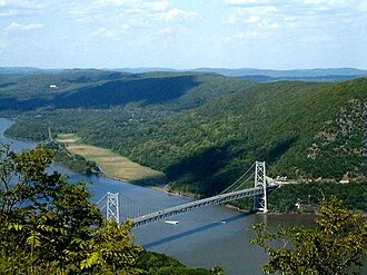
The Hudson River runs through the Munsee (Lenape), Mohican, and Mohawk (Haudenosaunee) homelands. Prior to European exploration, the river was known as the Mahicannittuk by the Mohicans, Ka'nón:no by the Mohawks, and Muhheakantuck by the Lenape. The river was subsequently named after Henry Hudson, an Englishman sailing for the Dutch East India Company who explored it in 1609, and after whom Hudson Bay in Canada is also named.
It had previously been observed by Italian explorer Giovanni da Verrazzano sailing for King Francis I of France in 1524, as he became the first European known to have entered the Upper New York Bay, but he considered the river to be an estuary. The Dutch called the river the North River, and they called the present-day Delaware River the South River, which formed the spine of the Dutch colony of New Netherland.
Settlements of the colony clustered around the Hudson, and its strategic importance as the gateway to the American interior led to years of competition between the English and the Dutch over control of the river and colony.
In the eighteenth century, the river valley and its inhabitants were the subject and inspiration of Washington Irving, the first internationally acclaimed American author. In the nineteenth century, the area inspired the Hudson River School of landscape painting, an American pastoral style, as well as the concepts of environmentalism and wilderness.
The Delaware and Hudson Canal connected Port Jervis on the Delaware river to Kingston on the Hudson, creating an inland route for coal from Pennsylvania to New York that bypassed the dangerous coastal route.[citation needed] The Erie Canal, completed in 1825, connected Albany on the Hudson to Buffalo on Lake Erie and therefore New York to the Great Lakes, becoming an important route for western settlers.[citation needed]
Industrial contamination of the Hudson River grew sharply in the mid-twentienth century, particularly from polychlorinated biphenyls, or PCBs. Pollution control regulations, enforcement actions, and restoration projects initiated in the late twentieth and twenty-first centuries have begun to improve water quality. Sturgeon have been seen in the Hudson in the early twenty-first century.
Names
The river was called Ka’nón:no or Ca-ho-ha-ta-te-a ("the river") by the Haudenosaunee, and it was known as Muh-he-kun-ne-tuk ("river that flows two ways" or "waters that are never still") or Mahicannittuk by the Mohican nation who formerly inhabited both banks of the lower portion of the river.
The meaning of the Mohican name comes from the river's long tidal range. The Delaware Tribe of Indians (Bartlesville, Oklahoma) considers the closely related Mohicans to be a part of the Lenape people, and so the Lenape also claim the Hudson as part of their ancestral territory, also calling it Muhheakantuck.
The first known European name for the river was the Rio San Antonio as named by the Portuguese explorer in Spain's employ, Estêvão Gomes, who explored the Mid-Atlantic coast in 1525. Another early name for the Hudson used by the Dutch was Rio de Montaigne. Later, they generally termed it the Noortrivier, or "North River", the Delaware River being known as the Zuidrivier, or "South River".
Other occasional names for the Hudson included Manhattes rieviere "Manhattan River", Groote Rivier "Great River", and de grootte Mouritse reviere, or "the Great Maurits River" (after Maurice, Prince of Orange).
The translated name North River was used in the New York metropolitan area up until the early 1900s, with limited use continuing into the present day. The term persists in radio communication among commercial shipping traffic, especially below the Tappan Zee. The term also continues to be used in names of facilities in the river's southern portion, such as the North River piers, North River Tunnels, and the North River Wastewater Treatment Plant.
It is believed that the first use of the name Hudson River in a map was in a map created by the cartographer John Carwitham in 1740.[disputed – discuss]
In 1939, the magazine Life described the river as "America's Rhine", comparing it to the 760-mile (1,220 km) Rhine in Central and Western Europe.
The tidal Hudson is unusually straight for a river, and the earliest colonial Dutch charts of the Hudson River designated the narrow, meandering stretches as racks, or reaches. These names included the four "lower reaches" through the Hudson Highlands (Seylmakers rack, Cocks rack, Hoogh rack, and Vosserack) plus the four "upper reaches" from Inbocht Bay to Kinderhook (Backers rack, Jan Pleysiers rack, Klevers rack, and Harts rack).
A ninth reach was described as "the long reach" by the Englishman Robert Juet and designated as the Langerack by the Dutch. An embellished (and partly erroneous) list of "The Old Reaches" was published in a tourist guidebook for steamboat passengers in the nineteenth century.