
















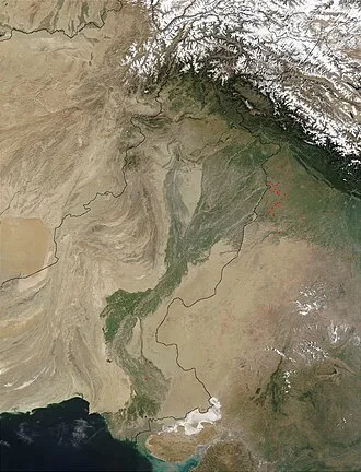
The Indus River has a total drainage area of circa 1,120,000 km2 (430,000 mi2). Its estimated annual flow is around 175 km3/a (5,500 m3/s), making it one of the 50 largest rivers in the world in terms of average annual flow. Its left-bank tributary in Ladakh is the Zanskar River, and its left-bank tributary in the plains is the Panjnad River which is formed by the successive confluences of the five Punjab rivers, namely the Chenab, Jhelum, Ravi, Beas, and Sutlej rivers.
Its principal right-bank tributaries are the Shyok, Gilgit, Kabul, Kurram, and Gomal rivers. Beginning in a mountain spring and fed with glaciers and rivers in the Himalayan, Karakoram, and Hindu Kush ranges, the river supports the ecosystems of temperate forests, plains, and arid countryside.
Geologically, the headwaters of the Indus and to their east those of the Yarlung Tsangpo (later in its course, the Brahmaputra) flow along the Indus-Yarlung suture zone, which defines the boundary along which the Indian plate collided with the Eurasian plate in the Early Eocene (approximately 50 Million years ago). These two Eurasian rivers, whose courses were continually diverted by the rising Himalayas, define the western and eastern limits, respectively, of the mountain range.
After the Indus debouches from its narrow Himalayan valley, it forms, along with its tributaries, the Punjab region of South Asia. The lower course of the river ends in a large delta.
Historically, the Indus was important to many cultures. The 3rd millennium BC saw the rise of Indus Valley Civilisation, a major urban civilization of the Bronze Age. During the 2nd millennium BC, the Punjab region was mentioned in the Rigveda hymns as Sapta Sindhu and in the Avesta religious texts as Hapta Həndu (both terms meaning "seven rivers").
Early historical kingdoms that arose in the Indus Valley include Gandhāra and Sindhu-Sauvīra. The Indus River came into the knowledge of the Western world early in the classical period, when King Darius of Persia sent his Greek subject Scylax of Caryanda to explore the river, c. 515 BC.
Etymology and names
The English language word "Indus" comes from Late Latin Indus (1598), specifically a use of Classical Latin Indus (inhabitant of India, Indian) from ancient Greek Ἰνδός "inhabitant of India, Indian, the River Indus", in turn from Old Persian Hindu, denoting an eastern province of the Achaemenid Empire (hind India, see Hindush), and Avestan hiṇdu, həṇdu "river"; with same Proto Indo-Iranian language-root as Sanskrit sindhu (IPA: [sin̪d̪ʰu], river); hence also the region of the Indus, from which also derive Hellenistic Greek Σίνθος "the River Indus" and Hindustan "land of the river Indus." The river's traditional name in Sanskrit and Tibetan is "Sindhu". In Sanskrit, its range of meanings includes: stream, river; Indus; flood; sea or ocean; region or country in the vicinity of the Indus, Sindh, people of Sindh."
The modern name in Urdu is Sindh or Daryā-i-Sindh, contrasting to the Province of Sindh. The Ladakhis and Tibetans call the river Senge Tsangpo (སེང་གེ་གཙང་པོ།), Baltis call it Gemtsuh and Tsuh-Fo, Pashtuns call it Sher Darya and Abbasin, while Sindhis call it Sindhu, Mehran, Purali and Samundar.
Description
The Indus River provides key water resources for Pakistan's economy – especially the breadbasket of Punjab province, which accounts for most of the nation's agricultural production. The word Punjab means "land of five rivers" and the five rivers are Jhelum, Chenab, Ravi, Beas and Sutlej, all of which finally flow into the Indus. The Indus also supports many heavy industries and provides the main supply of potable water in Pakistan.
The total length of the river varies in different sources. The length used in this article is 3,180 km (1,980 mi), taken from the Himalayan Climate and Water Atlas (2015). Historically, the 1909 The Imperial Gazetteer of India gave it as "just over 1,800 miles". A shorter figure of 2,880 km (1,790 mi) has been widely used in modern sources, as has the one of 3,180 km (1,980 mi).
The modern Encyclopedia Britannica was originally published in 1999 with the shorter measurement, but was updated in 2015 to use the longer measurement. Both lengths are commonly found in modern publications; in some cases, both measurements can be found within the same work. An extended figure of circa 3,600 km (2,200 mi) was announced by a Chinese research group in 2011, based on a comprehensive remeasurement from satellite imagery, and a ground expedition to identify an alternative source point, but detailed analysis has not yet been published.
The ultimate source of the Indus is in Tibet, but there is some debate about the exact source. The traditional source of the river is the Sênggê Kanbab (Sênggê Zangbo) or "Lion's Mouth", a perennial spring not far from the sacred Mount Kailash, marked by a long low line of Tibetan chortens. There are several other tributaries nearby, which may form a longer stream than Sênggê Kanbab, but unlike the Sênggê Kanbab, are all dependent on snowmelt.
The Zanskar River, which flows into the Indus in Ladakh, has a greater volume of water than the Indus itself before that point. An alternative reckoning begins the river around 300 km further upstream, at the confluence of the Sênggê Zangbo and Gar Tsangpo rivers, which drain the Nganglong Kangri and Gangdise Shan (Gang Rinpoche, Mt.
Kailash) mountain ranges. The 2011 remeasurement suggested the source was a small lake northeast of Mount Kailash, rather than either of the two points previously used.
The Indus then flows northwest through Ladakh (Indian-administered Kashmir) and Baltistan and Gilgit (Pakistan-administered Kashmir), just south of the Karakoram range. The Shyok, Shigar and Gilgit rivers carry glacial waters into the main river. It gradually bends to the south and descends into the Punjab plains at Kalabagh, Pakistan.
The Indus passes gigantic gorges 4,500–5,200 metres (15,000–17,000 ft) deep near the Nanga Parbat massif. It flows swiftly across Hazara and is dammed at the Tarbela Reservoir. The Kabul River joins it near Attock. The remainder of its route to the sea is in the plains of the Punjab and Sindh, where the flow of the river becomes slow and highly braided.
It is joined by the Panjnad at Mithankot. Beyond this confluence, the river, at one time, was named the Satnad River (sat = "seven", nadī = "river"), as the river now carried the waters of the Kabul River, the Indus River and the five Punjab rivers. When the river passes Jamshoro, it ends in a large delta to the South of Thatta in the Sindh province of Pakistan.
The Indus is one of the few rivers in the world to exhibit a tidal bore. The Indus system is largely fed by the snow and glaciers of the Himalayas, Karakoram and the Hindu Kush ranges. The flow of the river is also determined by the seasons – it diminishes greatly in the winter while flooding its banks in the monsoon months from July to September.
There is also evidence of a steady shift in the course of the river since prehistoric times – it deviated westwards from flowing into the Rann of Kutch and adjoining Banni grasslands after the 1816 earthquake. As of 2011[update], Indus water flows into the Rann of Kutch during its floods breaching flood banks.
History
The major cities of the Indus Valley Civilisation, such as Harappa and Mohenjo-daro, date back to around 3300 BC, and represent some of the largest human habitations of the ancient world. The Indus Valley Civilisation extended from across northeast Afghanistan to Pakistan and northwest India, with an upward reach from east of the Jhelum River to Ropar on the upper Sutlej.
The coastal settlements extended from Sutkagan Dor at the Pakistan-Iran border to Kutch in modern Gujarat, India. There is an Indus site on the Amu Darya at Shortughai in northern Afghanistan, and the Indus site Alamgirpur at the Hindon River is located only 28 km (17 mi) from Delhi. To date, over 1,052 cities and settlements have been found, mainly in the general region of the Ghaggar-Hakra River and its tributaries.
Among the settlements were the major urban centres of Harappa and Mohenjo-daro, as well as Lothal, Dholavira, Ganeriwala, and Rakhigarhi. Only 40 Indus Valley sites have been discovered on the Indus and its tributaries. However, it is notable that majority of the Indus script seals and inscribed objects discovered were found at sites along the Indus river.
Some scholars believe that settlements of Gandhara grave culture of the early Indo-Aryans flourished in Gandhara from 1700 BC to 600 BC, when Mohenjo-daro and Harappa had already been abandoned.[citation needed]
The Rigveda describes several rivers, including one named "Sindhu". The Rigvedic "Sindhu" is thought to be the present-day Indus River. It is attested 176 times in its text, 94 times in the plural, and most often used in the generic sense of "river". In the Rigveda, notably in the later hymns, the meaning of the word is narrowed to refer to the Indus River in particular; for example, in the list of rivers mentioned in the hymn of Nadistuti sukta.
The Rigvedic hymns apply a feminine gender to all the rivers mentioned therein, except for the Brahmaputra.
The word "India" is derived from the Indus River. In ancient times, "India" initially referred to those regions immediately along the east bank of the Indus, where Punjab and Sindh are now but by 300 BC, Greek writers including Herodotus and Megasthenes were applying the term to the entire subcontinent that extends much farther eastward.
The lower basin of the Indus forms a natural boundary between the Iranian Plateau and the Indian subcontinent; this region embraces all or parts of the Pakistani provinces Balochistan, Khyber Pakhtunkhwa, Punjab and Sindh and the countries Afghanistan and India. The first West Eurasian empire to annex the Indus Valley was the Persian Empire, during the reign of Darius the Great.
During his reign, the Greek explorer Scylax of Caryanda was commissioned to explore the course of the Indus. It was crossed by the invading armies of Alexander. Still, after his Macedonians conquered the west bank—joining it to the Hellenic world, they elected to retreat along the southern course of the river, ending Alexander's Asian campaign.
Alexander's admiral Nearchus set out from the Indus Delta to explore the Persian Gulf, until reaching the Tigris. The Indus Valley was later dominated by the Mauryan and Kushan Empires, Indo-Greek Kingdoms, Indo-Scythians and Hepthalites. Over several centuries Muslim armies of Muhammad ibn al-Qasim, Mahmud of Ghazni, Muhammad of Ghor, Timur and Babur crossed the river to invade Sindh and Punjab, providing a gateway to the Indian subcontinent.
Geology
The Indus River is an antecedent river, meaning that it existed before the Himalayas and entrenched itself while they were rising.
The Indus River feeds the Indus submarine fan, which is the second largest sediment body on Earth. It consists of around 5 million cubic kilometers of material eroded from the mountains. Studies of the sediment in the modern river indicate that the Karakoram Mountains in northern Pakistan and India are the single most important source of material, with the Himalayas providing the next largest contribution, mostly via the large rivers of the Punjab (Jhelum, Ravi, Chenab, Beas and Sutlej).
Analysis of sediments from the Arabian Sea has demonstrated that five million years ago the Indus was not connected to these Punjab rivers which instead flowed east into the Ganga and were captured after that time. Earlier work showed that sand and silt from western Tibet was reaching the Arabian Sea by 45 million years ago, implying the existence of an ancient Indus River by that time.
The delta of this proto-Indus River has subsequently been found in the Katawaz Basin, on the Afghan-Pakistan border.
In the Nanga Parbat region, the massive amounts of erosion due to the Indus River following the capture and rerouting through that area are thought to bring middle and lower crustal rocks to the surface.
In November 2011, satellite images showed that the Indus River had re-entered India and was feeding the Great Rann of Kutch, Little Rann of Kutch and a lake near Ahmedabad known as Nal Sarovar. Heavy rains had left the river basin along with the Lake Manchar, Lake Hemal and Kalri Lake (all in modern-day Pakistan) inundated. This happened two centuries after the Indus River shifted its course westwards following the 1819 Rann of Kutch earthquake.
The Induan Age at the start of the Triassic Period of geological time is named for the Indus region.
Tributaries
- Gilgit River
- Hunza River
- Gomal River
- Zhob River
- Haro River
- Kabul River
- Swat River
- Chitral River (or Kunar River)
- Kurram River
- Panjnad River
- Chenab River
- Jhelum River
- Ravi River
- Satluj River
- Beas River
- Chenab River
- Shyok River
- Soan River
- Dras River (or Shingo River)
- Zanskar River
- Luni River
Wildlife
Accounts of the Indus Valley from the times of Alexander's campaign indicate a healthy forest cover in the region. The Mughal Emperor Babur writes of encountering rhinoceroses along its bank in his memoirs (the Baburnama). Extensive deforestation and human interference in the ecology of the Shivalik Hills has led to a marked deterioration in vegetation and growing conditions.
The Indus Valley regions are arid with poor vegetation. Agriculture is sustained largely due to irrigation works. The Indus River and its watershed have a rich biodiversity. It is home to around 25 amphibian species.
Mammals
The Indus River dolphin (Platanista indicus minor) is found only in the Indus River. It is a subspecies of the South Asian river dolphin. The Indus River dolphin formerly also occurred in the tributaries of the Indus River. According to the World Wildlife Fund it is one of the most threatened cetaceans with only about 1,816 still existing.
It is threatened by habitat degradation from the construction of dams and canals, entanglement in fishing gear, and industrial water pollution.
There are two otter species in the Indus River basin: the Eurasian otter in the northeastern highland sections and the smooth-coated otter elsewhere in the river basin. The smooth-coated otters in the Indus River represent a subspecies found nowhere else, the Sindh otter (Lutrogale perspicillata sindica).
Fish
The Indus River basin has high diversity, being the home of more than 180 freshwater fish species, including 22 which are found nowhere else. Fish also played a major role in earlier cultures of the region, including the ancient Indus Valley Civilisation where depictions of fish were frequent. The Indus script has a commonly used fish sign, which in its various forms may simply have meant "fish", or referred to stars or gods.