














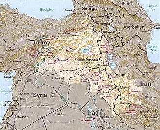
Kurdistan generally comprised the following four regions: southeastern Turkey (Northern Kurdistan), northern Iraq (Southern Kurdistan), northwestern Iran (Eastern Kurdistan), and northern Syria (Western Kurdistan). Some definitions also include parts of southern Transcaucasia. Certain Kurdish nationalist organizations seek to create an independent nation state consisting of some or all of these areas with a Kurdish majority, while others campaign for greater autonomy within the existing national boundaries.
The delineation of the region remains disputed and varied, with some maps greatly exaggerating its boundaries.
Historically, the word "Kurdistan" is first attested in 11th century Seljuk chronicles. Many disparate Kurdish dynasties, emirates, principalities, and chiefdoms were established from the 8th to 19th centuries. Administratively, the 20th century saw the establishment of the short-lived areas of the Kurdish state (1918–1919), Kingdom of Kurdistan (1921–1924), Kurdistansky Uyezd i.e. "Red Kurdistan" (1923–1929), Republic of Ararat (1927–1930), and Republic of Mahabad (1946).
In Iraq, following the Aylūl Revolt, the government entered into an agreement with the rebellious Kurds, granting Kurds local self-rule. Soon after, however, the agreement collapsed. Later, during the Iraqi no-fly zones conflict, which followed the Gulf War, the Iraqi military withdrew from parts of northern Iraq, allowing the Kurds to fill the vacuum and regain lost control in those areas.
After the invasion of Iraq, and since the creation of the new Iraqi federal state, the new constitution issued in 2005 recognises Kurdistan Region as a federal region; even though the constitution does not include the term "autonomy", it emphasises decentralisation and devolution, allowing regions and governorates to administer local affairs.
In practice, however, only Kurdistan Region has exercised this authority granted by the constitution. In September 2017, Iraqi Kurds held a one-sided independence referendum, which eventually failed and was abandoned. The subsequent effort by the Iraqi government to punish Kurdistan Region has resulted in the latter losing authorities it had previously possessed, and the future of Kurdish autonomy in Iraq has been called into question.
Iraqi Kurdish officials have also complained of efforts by the Iraqi government to return to the pre-2003 centralized government and dismantle Kurdistan Region altogether.
There is also a Kurdistan province in Iran, which is not self-ruled. Kurds fighting in the Syrian civil war, under the banner of the Syrian Democratic forces, established the Democratic Autonomous Administration of North and East Syria (commonly called Rojava), a self-governing administration which seeks to retain its autonomy in a proposed federalized Syria.
Etymology and delineation
Kurdistan means "Land of the Kurds" and was first attested in 11th-century Seljuk chronicles. The exact origins of the name Kurd are unclear. The suffix -stan (Persian: ـستان, stân) is Persian for land.
"Kurdistan" was also formerly spelled Curdistan. One of the ancient names of this region was Corduene. The 19th-century Kurdistan Eyalet was the first time that the Ottoman Empire used the term 'Kurdistan' to refer to an administrative unit rather than a geographical region.
Albeit admitting a thorough delineation is difficult, the Encyclopaedia of Islam delineated Kurdistan as following:
In Turkey, the Kurds inhabit the whole of the eastern region of the country. According to Trotter (1878), the limit of their extent to the north was the line Divriği—Erzurum—Kars... The Kurds also occupy the western slopes of Ararat, the districts of Kağızman and Tuzluca. On the west they extend in a wide belt beyond the course of the Euphrates, and, in the region of Sivas, in the districts of Kangal and Divriği.
Equally, the whole region includes areas to the east and south-east of these limits... Turkish Kurdistan numbers at least 17 of them almost totally: in the north-east, the provinces of Erzincan, Erzurum and Kars; in the centre, going from west to east and from north to south, the provinces of Malatya, Tunceli, Elazığ, Bingöl, Muş, Karaköse (Ağrı), then Adıyaman, Diyarbakır, Siirt, Bitlis and Van; Finally, the southern provinces of Şanlıurfa, Mardin and Çölamerik (Hakkâri)...
[Kurds] inhabit the north-west of Iran. Firstly in the provinces of West Azerbaijan, to the east of Lake Rida'iyya..., the districts of Maku, Kotur, Shahpur, and to the south of the lake, Mahabad (ex-Sabla); in the province of Ardalan, called the province of Kurdistan, whose capital is Senna or Sanandaj, Hawraman; in the province of Kermanshah, Qasr-e Shirin...
In Iraq, the Kurds occupy the north and northeast of the country in the liwaʾs or provinces of Duhok... Left outside their administration are Sinjar and Shekhan, peopled by the Yazidis; the liwaʾs of Kirkuk, Arbil and Sulaymaniyah (entirely Kurdish) and, in the... nahiyas of Khanaqin and Mandali, where they are neighbours of the Kurds of Iran to the west of the Zagros.
In Syria, they constitute three distinct belts, in the north of the country and to the south of the highway which forms a frontier and where they are in direct contact with their compatriots in Turkey... [I]n the Kurd Dagh;..., to the east of the Euphrates where the river enters Syria near Jarablus; and finally, a belt of 250 km. in length by 30 km. in depth in the Jazira.
Many of the maps delineating Kurdistan are greatly exaggerated, also incorporating non-Kurdish regions, which has made the subject very controversial.
History
Ancient history
Various groups, among them the Guti, Hurrians, Mannai (Mannaeans), and Armenians, lived in this region in antiquity. The original Mannaean homeland was situated east and south of the Lake Urmia, roughly centered around modern-day Mahabad. The region came under Persian rule during the reign of Cyrus the Great and Darius I.
The Kingdom of Corduene, which emerged from the declining Seleucid Empire, was located to the south and south-east of Lake Van between Persia and Mesopotamia and ruled northern Mesopotamia and southeastern Anatolia from 189 BC to AD 384 as vassals of the vying Parthian and Roman empires. Corduene became a vassal state of the Roman Republic in 66 BC and remained allied with the Romans until AD 384.
After 66 BC, it passed another 5 times between Rome and Persia. Corduene was situated to the east of Tigranocerta, that is, to the east and south of present-day Diyarbakır in south-eastern Turkey.
Some historians have correlated a connection between Corduene with the modern names of Kurds and Kurdistan; T. A. Sinclair and other scholars have dismissed this identification as false, while a common association is asserted in the Columbia Encyclopedia.
Some of the ancient districts of Kurdistan and their corresponding modern names:
- Corduene or Gordyene (Siirt, Bitlis and Şırnak)
- Sophene (Diyarbakır)
- Zabdicene or Bezabde (Gozarto d'Qardu or Jazirat Ibn or Cizre)
- Basenia (Bayazid)
- Moxoene (Muş)
- Nephercerta (Miyafarkin)
- Artemita (Van)
One of the earliest records of the phrase land of the Kurds is found in an Assyrian Christian document of late antiquity, describing the stories of Assyrian saints of the Middle East, such as Abdisho. When the Sasanian Marzban asked Mar Abdisho about his place of origin, he replied that according to his parents, they were originally from Hazza, a village in Assyria.
However, they were later driven out of Hazza by pagans, and settled in Tamanon, which according to Abdisho was in the land of the Kurds. Tamanon lies just north of the modern Iraq-Turkey border, while Hazza is 12 km southwest of modern Erbil. In another passage in the same document, the region of the Khabur River is also identified as land of the Kurds.
According to Al-Muqaddasi and Yaqut al-Hamawi, Tamanon was located on the south-western or southern slopes of Mount Judi and south of Cizre. Other geographical references to the Kurds in Syriac sources appear in Zuqnin chronicle, writings of Michael the Syrian and Bar Hebraeus. They mention the mountains of Qardu, city of Qardu and country of Qardawaye.
Post-classical history
In the tenth and eleventh centuries, several Kurdish principalities emerged in the region: in the north the Shaddadids (951–1174) (in east Transcaucasia between the Kur and Araxes rivers) and the Rawadids (955–1221) (centered on Tabriz and which controlled all of Azerbaijan), in the east the Hasanwayhids (959–1015) (in Zagros between Shahrizor and Khuzistan) and the Annazids (990–1116) (centered in Hulwan) and in the west the Marwanids (990–1096) to the south of Diyarbakır and north of Jazira.
Kurdistan in the Middle Ages was a collection of semi-independent and independent states called emirates. It was nominally under indirect political or religious influence of Khalifs or Shahs. A comprehensive history of these states and their relationship with their neighbors is given in the text of Sharafnama, written by Prince Sharaf al-Din Bitlisi in 1597.
The emirates included Baban, Soran, Badinan and Garmiyan in the south; Bakran, Bohtan (or Botan) and Badlis in the north, and Mukriyan and Ardalan in the east.
The earliest medieval attestation of the toponym Kurdistan is found in a 12th-century Armenian historical text by Matteos Urhayeci. He described a battle near Amid and Siverek in 1062 as to have taken place in Kurdistan. The second record occurs in the prayer from the colophon of an Armenian manuscript of the Gospels, written in 1200.
A later use of the term Kurdistan is found in Empire of Trebizond documents in 1336 and in Nuzhat al-Qulub, written by Hamdallah Mustawfi in 1340.
According to Sharaf al-Din Bitlisi in his Sharafnama, the boundaries of the Kurdish land begin at the Strait of Hormuz in the Persian Gulf and stretch on an even line to the end of Malatya and Marash. Evliya Çelebi, who traveled in the region between 1640 and 1655, mentioned that Kurdistan includes Erzurum, Van, Hakkari, Cizre, Imaddiya, Mosul, Shahrizor, Harir, Ardalan, Baghdad, Derne, Derteng, until Basra.
In the 16th century, after prolonged wars, Kurdish-inhabited areas were split between the Safavid and Ottoman empires. A major division of Kurdistan occurred in the aftermath of the Battle of Chaldiran in 1514, and was formalized in the 1639 Treaty of Zuhab. In a geography textbook of late Ottoman military school by Ahmet Cevad Kurdistan span over the cities Erzurum, Van, Urfa, Sulaymanyah, Kirkuk, Mosul and Diyarbakir among others and was one out of six regions of Ottoman Asia.
Modern history
After the collapse of the Ottoman Empire, the Allies contrived to split Kurdistan (as detailed in the ultimately unratified Treaty of Sèvres) among several countries, including Kurdistan, Armenia and others. However, the reconquest of these areas by the forces of Kemal Atatürk (and other pressing issues) caused the Allies to accept the renegotiated Treaty of Lausanne (1923) and the borders of the modern Republic of Turkey, leaving the Kurds without a self-ruled region. Other Kurdish areas were assigned to the new British and French mandated states of Iraq and Syria.
At the San Francisco Peace Conference of 1945, the Kurdish delegation proposed consideration of territory claimed by the Kurds, which encompassed an area extending from the Mediterranean shores near Adana to the shores of the Persian Gulf near Bushehr, and included the Lur inhabited areas of southern Zagros.
The historian Jordi Tejel has identified "Greater Kurdistan" as being one of the "Kurdish myths" that the Kurdistan Democratic Party of Syria (KDPS) were involved in promoting to Kurds in Syria.
An academic source published by the University of Cambridge has described maps of greater Kurdistan created in the 1940s and forward as: "These maps have become some of the most influential propaganda tools for the Kurdish nationalist discourse. They depict a territorially exaggerated version of the territory of Kurdistan, extending into areas with no majority Kurdish populations.
Despite their production with political aims related to specific claims on the demographic and ethnographic structure of the region, and their questionable methodologies, they have become 'Kurdistan in the minds of Kurds' and the boundaries they indicate have been readily accepted."
At the end of the 1991 Gulf War, the Coalition established a no-fly zone over northern Iraq to provide humanitarian relief to and safeguard the Kurds who would be subjected to Iraqi air attacks. Amid the withdrawal of Iraqi forces from three northern provinces, Kurdistan Region emerged in 1992 as an autonomous entity inside Iraq with its own local government and parliament.
A 2010 US report, written before the instability in Syria and Iraq that exists as of 2014, attested that "Kurdistan may exist by 2030". The weakening of the Iraqi state following the 2014 Northern Iraq offensive by the Islamic State of Iraq and the Levant has also presented an opportunity for independence for Iraqi Kurdistan, augmented by Turkey's move towards acceptance of such a state although it opposes moves toward Kurdish autonomy in Turkey and Syria.
Northern Kurdistan
The incorporation into Turkey of the Kurdish-inhabited regions of eastern Anatolia was opposed by many Kurds, and has resulted in a long-running separatist conflict in which tens of thousands of lives have been lost. The region saw several major Kurdish rebellions, including the Koçgiri rebellion of 1920 against the Grand National Assembly, then successive insurrections under the Turkish state, including the 1924 Sheikh Said rebellion, the Republic of Ararat in 1927, and the 1937 Dersim rebellion.
All were forcefully put down by the authorities. The region was declared a closed military area from which foreigners were banned between 1925 and 1965.
In an attempt to deny their existence, the Turkish government categorized Kurds as "Mountain Turks" until 1991. The words "Kurds", "Kurdistan", or "Kurdish" were officially banned by the Turkish government. Following the military coup of 1980, the Kurdish language was officially prohibited in public and private life. Many people who spoke, published, or sang in Kurdish were arrested and imprisoned. Throughout the 1990s and early 2000s, political parties that represented Kurdish interests were banned.