The city boundaries roughly correspond to the basin of the Lhasa River, a major tributary of the Yarlung Tsangpo River. It lies on the Lhasa terrane, the last unit of crust to accrete to the Eurasian plate before the continent of India collided with Asia about 50 million years ago and pushed up the Himalayas. The terrain is high, contains a complex pattern of faults and is tectonically active.
The temperature is generally warm in summer and rises above freezing on sunny days in winter. Most of the rain falls in summer. The upland areas and northern grasslands are used for grazing yaks, sheep and goats, while the river valleys support agriculture with crops such as barley, wheat and vegetables. Wildlife is not abundant, but includes the rare snow leopard and black-necked crane. Mining has caused some environmental problems.
The 2000 census gave a total population of 474,490, of whom 387,124 were ethnic Tibetans. The Han Chinese population at the time was mainly concentrated in urban areas. The prefecture-level city is traversed by two major highways and by the Qinghai–Tibet railway, which terminates in the city of Lhasa. In the future, the Sichuan–Tibet railway currently under construction will expect to start operations in 2030.
Two large dams on the Lhasa River deliver hydroelectric power, as do many smaller dams and the Yangbajain Geothermal Field. The population is well-served by primary schools and basic medical facilities, although more advanced facilities are lacking.
Tibetan Buddhism and monastic life have been dominant aspects of the local culture since the 7th century. Most of the monasteries were destroyed during the Cultural Revolution, but since then many have been restored and serve as tourist attractions.
History
Lhasa is the capital and largest city in Tibet. Founded in the 5th century AD and largely closed to foreigners until the early 1980s, its name means "God's Home" or "City of the Gods" and is still very much a pilgrimage destination among Tibetans. After several conflicts of the Mongol invasions and the Qing rule of Tibet, the British led by Francis Younghusband led the expeditions of Tibet.
In 1912, the Qing collapse led to Tibet becoming independent on 4 April 1912 with Thubten Gyatso as "the Great Thirteenth" for Tibet's national independence from Qing rule.
The annexation of Tibet by the People's Republic of China took place as Tenzin Gyatso, the 14th Dalai Lama, fled to McLeod Ganj, India in 1959 at the end of the Tibetan uprising.
Geography
Location
Lhasa lies in south-central Tibet, to the north of the Himalayas. The prefecture-level city is 277 kilometres (172 mi) from east to west and 202 kilometres (126 mi) from north to south. It covers an area of 29,518 square kilometres (11,397 sq mi).[citation needed] It is bordered by Nagqu City to the north, Nyingchi City to the east, Shannan/Lhoka City to the south and Xigazê City to the west.
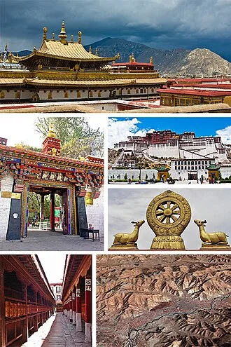
The prefecture-level city roughly corresponds to the basin of the Lhasa River, which is the center of Tibet politically, economically and culturally. Chengguan District is also the center of Tibet in terms of transport, communications, education and religion, as well as being the most developed part of Tibet and a major tourist destination with sights such as the Potala Palace, Jokhang and Ramoche Temple.[citation needed]
Lhasa River basin
Lhasa prefecture-level city roughly corresponds to the basin of the Lhasa River, a major tributary of the Yarlung Tsangpo. Exceptions are the north of Damxung County, which crosses the watershed of the Nyenchen Tanglha Mountains and includes part of the Namtso lake, and Nyêmo County, which covers the basin of the Nimu Maqu River, a direct tributary of the Yarlung Tsangpo.[citation needed] The river basin is separated from the Yarlung Tsangpo valley to the south by the Goikarla Rigyu range.
The largest tributary of the Lhasa River, the Reting Tsangpo, originates in the Chenthangula Mountains in Nagqu Prefecture at an elevation of about 5,500 metres (18,000 ft), and flows southwest into Lhasa past Reting Monastery.
The Lhasa River drains an area of 32,471 square kilometres (12,537 sq mi), and is the largest tributary of the middle section of the Yarlung Tsangpo. The average altitude of the basin is around 4,500 metres (14,800 ft). The basin has complex geology and is tectonically active. Earthquakes are common. Annual runoff is 10,550,000,000 cubic metres (3.73×10¹¹ cu ft). Water quality is good, with little discharge of sewage and minimal chemical pesticides and fertilizers.
The Lhasa River forms where three smaller rivers converge. These are the Phak Chu, the Phongdolha Chu which flows from Damxung County and the Reting Tsangpo, which rises beyond the Reting Monastery. The highest tributary rises at around 5,290 metres (17,360 ft) on the southern slope of the Nyenchen Tanglha Mountains.
In its upper reaches, the river flows southeast through a deep valley. Lower down the river valley is flatter and changes its direction to the southwest, The river expands to a width of 150 to 200 metres (490 to 660 ft). Major tributaries in the lower reaches include the Pengbo River and the Duilong River. At its mouth, the Lhasa Valley is about 3 miles (4.8 km) wide.
The bulk of the water is supplied by the summer monsoon rains, which fall from July to September. There are floods in the summer from July to September, with about 17% of the annual runoff flowing in September. In winter the river has low water, and sometimes freezes. Total flow is about 4 cubic kilometres (0.96 cu mi), with average flow about 125 cubic metres per second (4,400 cu ft/s).
The total hydropower potential of the river basin is 2,560,000 kW. Zhikong Hydro Power Station in Maizhokunggar County delivers 100 MW. The Pangduo Hydro Power Station in Lhünzhub County has total installed capacity of 160 MW.
Geology
The former Lhasa prefecture lies in the Lhasa terrane, to which it gives its name. This is thought to be the last crustal block to accrete to the Eurasian plate before the collision with the Indian plate in the Cenozoic. The terrane is separated from the Himalayas to the south by the Yarlung-Tsangpo suture, and from the Qiangtang terrane to the north by the Bangong-Nujiang suture.
The Lhasa terrane consisted of two blocks before the Mesozoic, the North Lhasa Block and the South Lhasa Block. These blocks were joined in the Late Paleozoic.
The Lhasa terrane moved northward and collided with the Qiangtang terrane along the Bangong suture. The collision began towards the end of the late Jurassic (c. 163–145 Ma), and collision activity continued until the early Late Cretaceous (c. 100–66 Ma).
During this period the terrane may have been shortened by at least 180 kilometres (110 mi). The collision caused a peripheral foreland basin to form in the north part of the Lhasa terrane. In some parts of the foreland basin the north-dipping subduction of the Neotethyan oceanic crust below the Lhasa terrane caused volcanism.
The Gangdese batholith was formed as this subduction continued along the southern margin of the Lhasa terrane. The Gangdese intrudes the southern half of the Lhasa terrain.
Contact with India began along the Yarlung-Zangbo suture around 50 Ma during the Eocene, and the two continents continue to converge. Magmatism continued in the Gangdese arc until as late as 40 Ma. There was significant crustal shortening as the collision progressed. The South Lhasa terrane experienced metamorphism and magmatism in the Early Cenozoic (55–45 Ma) and metamorphism in the Late Eocene (40–30 Ma), presumably due to the collision between the continents of India and Eurasia.
Rocks in this region include sedimentary rocks from the Paleozoic and Mesozoic into which granite has intruded during the Cretaceous. The rocks have metamorphosed and are deeply eroded and faulted. The rocks exposed in the Reting Tsangpo canyon range in age from 400 Ma to 50 Ma. The result of faulting has been to often juxtapose relatively recent rocks with much older rocks.
Some parts of the ocean floor were pushed up onto the Tibetan Plateau and formed marble or slate. Sea fossils from 400 Ma are found in the river's canyons, and houses are roofed with slate.
The Yangbajing Basin lies between the Nyainquentanglha Range to the northwest and the Yarlu-Zangbo suture to the south. The Yangbajain Geothermal Field is in the central part of a half-graben fault-depression basin caused by the foremontane fault zone of the Nyainqentanglha Mountains. The SE-dipping detachment fault began to form about 8 Ma.
The geothermal reservoir is basically a Quaternary basin underlaid by a large granite batholith. The basin has been filled with glacial deposits from the north and alluvial-pluvial sediments from the south. Fluid flows horizontally into the reservoir through the faults around the basin. Chemical analysis of the thermal fluid indicate that there is shallow-seated magmatic activity not far below the geothermal field.
During the ice ages of the last two million years, the Tibetan plateau and the Himalayas have been covered by the expanded polar ice cap several times. As the ice moved it eroded the rock, filling the river canyons with gravel. In some sections the rivers have cut through the gravel and flow swiftly over bedrock, and in some areas large boulders have fallen into the rivers and formed rapids.
Climate
The Lhasa valley is roughly the same latitude as the southern United States, but at an altitude of 3,610 metres (11,840 ft) or more it is cooler. The central river valleys of Tibet are warm in summer, and even in the coldest months of winter the temperature is above freezing on sunny days. The climate is semi-arid monsoon, with a low average temperature of 1.2 to 7.5 °C (34.2 to 45.5 °F).
Average annual precipitation is 466.3 millimetres (18.36 in), with 85% falling in the June–September period. Typically, there are 3,000 hours of sunshine each year.[citation needed] It is cooler in the northern regions, warmer in the south. Annual figures:
Studies of temperature and precipitation data from 1979 to 2005 indicate that higher temperatures are leading to longer snow-free periods at the lower elevations. However, at higher levels the amount of precipitation has increased, so despite warming the snow-free period is shorter.
Environment
Most of the population of Tibet lives in the southern valleys, including those around Lhasa. The higher regions are used by nomadic drokpa who tend herds of yaks, sheep and goats on the steppe grasslands of the hills and high valleys. In the lower parts it is possible to cultivate products that include barley, wheat, black peas, beans, mustard, hemp, potatoes, cabbage, cauliflower, onions, garlic, celery and tomatoes.
The traditional staple food is barley flour called tsampa, often combined with buttered tea and made into a paste.
A visitor described the valley around Lhasa in 1889 as follows,
The plain over which we are riding is a wonderfully fruitful one. It is skirted on the south by the Kyi river, and is watered, moreover, by another smaller stream from the north, which flows into the Kyi ... some five miles west of Lhasa. All this land is carefully irrigated by means of dikes and cross-channels from both rivers.
Fields of buckwheat, barley, pea, rape, and lindseed lie in orderly series everywhere. The meadows near the water display the richest emerald-green pasturage. Groves of poplar and willow, in shapely clumps, combine with the grassy stretches to give in places a parklike appearance to the scene. Several hamlets and villages, such as Cheri, Daru, and Shing Dongkhar, are dotted over these lands. A fertile plain truly for a besieging army!
The Lhasa region does not have abundant wildlife or great numbers of species, but the Lhasa valley does support wintering populations of hundreds of black-necked cranes. Hutoushan Reservoir lies in Qangka Township, Lhünzhub County. The reservoir is bordered by large swamps and wet meadows, and has abundant plants and shellfish.
The reservoir, which lies in the Pengbo valley, is the largest in Tibet, with total storage of 12,000,000 cubic metres (420,000,000 cu ft). Endangered black-necked cranes migrate to the middle and southern part of Tibet every winter, and may be seen on the reservoir and elsewhere in the Lhasa region. Other wildlife includes bharal, pheasants, roe deer, Thorold's deer, Mongolian gazelle, Siberian ibex, otter, brown bear, snow leopard and duck.
Medicinal plants include fritillaries (fritillaria), stonecrop (rhodiola), Indian barberry (berberis aristata), Chinese caterpillar fungus (ophiocordyceps sinensis), codonopsis and Lingzhi mushroom (ganoderma).
The dams on the Lhasa river built as part of the Three Rivers Development Project are unlikely to affect the flow of the Brahmaputra in India. However, the climate and soil are unsuitable for large-scale irrigation. Where grasslands have been converted into irrigated farms fed by dams the result may damage the environment.
Jama wetland in Maizhokunggar County is vulnerable to grazing and climate change. Extensive mining in some mountainous regions have turned areas of what was green pasturage into a grey wasteland. The authorities are reported to have suppressed protests by the local people. Military personnel have been involved in efforts to protect and improve the environment, including replanting programs.
A 2015 study reported that during the non-monsoon season the levels of arsenic in the Duilong River, at 205.6 μg/L were higher than the WHO guideline of 10 μg/L for drinking water. The source of the pollution seems to be untreated water from the Yangbajain Geothermal Field power station. It can be detected 90 kilometres (56 mi) downstream from this site.
Administrative divisions
Lhasa prefecture-level city consists of three districts and five counties. Chengguan District, Doilungdêqên District, and Dagzê District contains most of the urban area of Lhasa, which lies in the Lhasa River valley floor.
Chengguan District
Chengguan District is located on the middle reaches of the Lhasa River, with land that rises to the north and south of the river. It is 28 kilometres (17 mi) from east to west and 31 kilometres (19 mi) from north to south. Chengguan District is bordered by Doilungdêqên District to the west, Dagzê District to the east and Lhünzhub County to the north.
Gonggar County of Lhoka (Shannan) City lies to the south.[citation needed] Chengguan District has an elevation of 3,650 metres (11,980 ft) and covers 525 square kilometres (203 sq mi).
The urban built-up area covers 60 square kilometres (23 sq mi). The average annual temperature is 8 °C (46 °F). Annual precipitation is about 500 millimetres (20 in), mostly falling between July and September.[citation needed]
Before the PRC takeover the city of Lhasa had a population of 25,000–30,000, or 45,000–50,000 if the large monasteries around the city are included. The old city formed a quadrangle about 3 square kilometres (1.2 sq mi) around the Jokhang temple, about 1 kilometre (0.62 mi) to the east of the Potala Palace.
During the period before the reforms introduced by Deng Xiaoping the old city of Lhasa was left largely intact, while bleakly functional compounds containing symmetrical dormitory-type buildings for both living and working were built apart from the city along the main roads.
By 1990 the city had expanded to cover 40 square kilometres (15 sq mi), with an official population of 160,000. The 2000 official census gave a total population of 223,001, of which 171,719 lived in the areas administered by sub-districts and residential committees. 133,603 had urban registrations and 86,395 had rural registrations, based on their place of origin.
By 2013 the urban area filled most of the natural Lhasa River valley in Chengguan District. A 2011 book estimated that up to two-thirds of the city's residents are non-Tibetan, although the government states that Chengguan District as a whole is still 63% ethnic Tibetan.
Doilungdêqên District
Doilungdêqên District contains the western urban areas of Lhasa, developed in recent years with the new Lhasa railway station, which begin about 12 kilometres (7.5 mi) from the city center. It covers an area of 2,704 square kilometers, with 94,969 acres of farmland. The district borders on the north Tibet grasslands in the northwest.
The valley of the Duilong River leads south to the Lhasa River. The Duilong is 95 kilometres (59 mi) in length. In the south the district occupies part of the south bank of the Lhasa River. The district has an average elevation of 4,000 metres (13,000 ft), with a highest elevation of 5,500 metres (18,000 ft) and a lowest point at 3,640 metres (11,940 ft).
There are about 120 frost-free days annually. Annual mean temperature is 7 °C (45 °F), with temperatures in January falling below −10 °C (14 °F) Annual precipitation is about 440 millimetres (17 in), with autumn rainfall of 310 millimetres (12 in). The district is agriculturally rich and was used by the Tibetan kings as a source of food for Lhasa.
The seat of government is in the town of Donggar. This is just 14 kilometres (8.7 mi) from downtown Lhasa. In 1992 there were 33,581 people in 6,500 households, with 94.28% of the people engaged in farming. About 90% of the people were ethnic Tibetan, with most people of other ethnicity living in Donggar. The main mineral resources are coal, iron, clay, lead and zinc.
Tsurphu Monastery, built in 1189, is treated as a regional cultural relic reserve. The Nechung Monastery, former home of the Nechung Oracle, is located in Naiquong township. Nechung was built by the 5th Dalai Lama (1617–82).
Dagzê District
Dagzê District has a total area of 1,373 square kilometres (530 sq mi) and it contains the eastern urban areas of Lhasa. It has an average elevation of 4,100 metres (13,500 ft) above sea level, and descends from higher ground in the north and south to 3,730 metres (12,240 ft) in the lowest part of the Lhasa River valley.
The average temperature is 7.5 °C (45.5 °F), with about 130 days free of frost. Average rainfall is 450 millimetres (18 in). About 80%–90% of precipitation falls in the summer.[citation needed]
As of 2013 the total population was 29,152. The main occupation is agriculture. As of 2012 per capita income of farmers and herdsmen was 6,740 yuan. In 2010 there were 28 schools in the district, including one junior high school and one kindergarten, with 276 full-time teachers. There is a district hospital and five township hospitals.
The Sichuan-Tibet Highway (China National Highway 318) runs through the district. The main monasteries in Dagzê are Ganden Monastery and Yerpa.[citation needed]
Damxung County
Damxung County has an area of 10,036 square kilometres (3,875 sq mi), with rugged topography. As of 2013 the population was 40,000, up from 35,000 in 1997.[citation needed] It is tectonically active.
On 6 October 2008 an earthquake measuring 6.6 on the Richter magnitude scale was reported. In November 2010 a moderate quake in Damxung at 5.2 on the Richter scale shook office windows in Lhasa. There were no casualties, but houses were damaged.
In the extreme northeast of the county, Namtso lake has an area of 1,920 square kilometres (740 sq mi), of which 45% lies in Damxung county. Namtso is one of the great lakes of the Tibetan plateau. The Nyenchen Tanglha (or Nyainqentanglha) mountains extend along the northwest of the county. Mount Nyenchen Tanglha is the highest peak in the region, at 7,111 metres (23,330 ft).
The Nyainqêntanglha mountains define the watershed between northern and southern Tibet.[citation needed] A valley with elevation of about 4,200 metres (13,800 ft) runs parallel to the mountains to their southeast, sloping from northwest to southeast. 30% of the county's total area is in the prairie of this valley.
Damxung is cold and dry in the winter, cool and wet in summer, with very variable weather. The average annual temperature is 1.3 °C (34.3 °F), with only 62 frost-free days. The land is frozen from the start of November to the following March. Pasture has 90–120 days for growth. Average annual precipitation is 481 millimetres (18.9 in).
Natural grasslands cover 693,171 hectares (1,712,860 acres), of which 68% is considered excellent. Almost all the people are engaged in rearing livestock, including yaks, sheep, goats and horses.