
















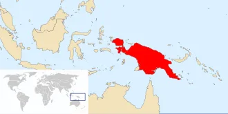
Located in Melanesia in the southwestern Pacific Ocean, the island is separated from Australia by the 150-kilometre (81-nautical-mile; 93-mile) wide Torres Strait, though both landmasses lie on the same continental shelf, and were united during episodes of low sea level in the Pleistocene glaciations as the combined landmass of Sahul.
Numerous smaller islands are located to the west and east. The island's name was given by Spanish explorer Yñigo Ortiz de Retez during his maritime expedition of 1545 because of the perceived resemblance of the indigenous peoples of the island to those in the African region of Guinea.
The eastern half of the island is the major land mass of the nation of Papua New Guinea. The western half, known as Western New Guinea, forms a part of Indonesia and is organized as the provinces of Papua, Central Papua, Highland Papua, South Papua, Southwest Papua, and West Papua. The two major cities on the island are Port Moresby and Jayapura.
Names
The island has been known by various names:
The name Papua was used to refer to parts of the island before contact with the West. Its etymology is unclear; one theory states that it derived from Tidore, the language used by the Sultanate of Tidore. An expedition by the Sultan of Tidore, together with Sahmardan, the Sangaji of Patani, and the Papuan Gurabesi, managed to conquer some areas in New Guinea, which was then reorganised to form Korano Ngaruha ("Four Kings") or Raja Ampat, Papoua Gam Sio (lit. "The Papua Nine Negeri"), and Mafor Soa Raha (lit. The Mafor "Four Soa").
The name comes from the words papo ("to unite") and ua (negation), which means "not united", i.e. an outlying possession of Tidore.
Anton Ploeg reports that the word papua is often said to be derived from the Malay word papua or pua-pua, meaning "frizzly-haired", referring to the very curly hair of the island's inhabitants. However Sollewijn Gelpke in 1993 considered this unlikely as it had been used earlier, and he instead derived it from the Biak phrase sup i babwa, which means "the land below [the sunset]", and refers to the Raja Ampat Islands.
When Portuguese and Spanish explorers arrived via the Spice Islands, they also used the name Papua. However, Westerners, beginning with Spanish explorer Yñigo Ortiz de Retez in 1545, used the name New Guinea, due to the resemblance between the indigenous peoples of the island and Africans of the Guinea region. The name is one of several toponyms sharing similar etymologies, ultimately meaning "land of the blacks" or similar meanings.
The Dutch, who arrived later under Jacob Le Maire and Willem Schouten, called it Schouten island. They later used this name only to refer to islands off the north coast of Papua proper, the Schouten Islands or Biak Island. When the Dutch colonized the main island as part of the Dutch East Indies, they called it Nieuw Guinea.
The name Irian was used in the Indonesian language to refer to the island and Indonesian province, as Irian Barat (West Irian) Province and later Irian Jaya Province. The name Irian was suggested during a tribal committee meeting in Tobati, Jayapura,[when?] formed by Soegoro Atmoprasodjo under governor J. P. van Eechoed, to decide on a new name because of the negative association of Papua.
Frans Kaisiepo, the committee leader, suggested the name from Mansren Koreri myths, Iri-an from the Biak language of Biak Island, meaning "hot land" (referring to the climate), but also from Iryan which means heated process as a metaphor for a land that is entering a new era. In Serui Iri-an (lit. "land-nation") means "pillar of nation", while in Merauke Iri-an (lit. "placed higher-nation") means "rising spirit" or "to rise".
The name was promoted in 1945 by Marcus Kaisiepo, brother of Frans Kaisiepo. The name was politicized later by Corinus Krey, Marthen Indey, Silas Papare, and others with the Indonesian backronym Ikut Republik Indonesia Anti Nederland ("Join the Republic of Indonesia Oppose the Netherlands"). Irian was used somewhat in 1972.
The name was used until 2001, when Papua was again used for the island and the province. The name Irian, which was originally favoured by natives, is now considered to be a name imposed by the Indonesian government.
Geography
New Guinea is an island to the north of the Australian mainland, south of the equator. It is isolated by the Arafura Sea to the west, and the Torres Strait and Coral Sea to the east. Sometimes considered to be the easternmost island of the Indonesian archipelago, it lies north of Australia's Top End, the Gulf of Carpentaria and Cape York Peninsula, and west of the Bismarck Archipelago and the Solomon Islands archipelago.
Biologically, New Guinea may also be considered part of Australia, as there is a continuity of flora and fauna between the two regions.
Politically, the western half of the island comprises six provinces of Indonesia: Papua, Central Papua, Highland Papua, South Papua, West Papua and Southwest Papua. The eastern half forms the mainland of the country of Papua New Guinea.
The shape of New Guinea is often compared to that of a bird-of-paradise (indigenous to the island), and this results in the usual names for the two extremes of the island: the Bird's Head Peninsula in the northwest (Vogelkop in Dutch, Kepala Burung in Indonesian; also known as the Doberai Peninsula), and the Bird's Tail Peninsula in the southeast (also known as the Papuan Peninsula).
A spine of east–west mountains, the New Guinea Highlands, dominates the geography of New Guinea, stretching over 1,600 km (1,000 mi) across the island, with many mountains over 4,000 m (13,100 ft). The western half of the island contains the highest mountains in Oceania, with its highest point, Puncak Jaya, reaching an elevation of 4,884 m (16,023 ft).
The tree line is around 4,000 m (13,100 ft) elevation, and the tallest peaks contain equatorial glaciers—which have been retreating since at least 1936. Various other smaller mountain ranges occur both north and west of the central ranges. Except in high elevations, most areas possess a warm humid climate throughout the year, with some seasonal variation associated with the northeast monsoon season.
Another major habitat feature is the vast southern and northern lowlands. Stretching for hundreds of kilometres, these include lowland rainforests, extensive wetlands, savanna grasslands, and some of the largest expanses of mangrove forest in the world. The southern lowlands are the site of Lorentz National Park, a UNESCO World Heritage Site.
The northern lowlands are drained principally by the Mamberamo River and its tributaries on the western side, and by the Sepik on the eastern side. The more extensive southern lowlands are drained by a larger number of rivers, principally the Digul in the west and the Fly in the east. The largest island offshore, Dolak, lies near the Digul estuary, separated by a strait so narrow it has been named a "creek".
New Guinea contains many of the world's ecosystem types: glacial, alpine tundra, savanna, montane and lowland rainforest, mangroves, wetlands, lake and river ecosystems, seagrasses, and some of the richest coral reefs on the planet.
The entire length of the New Guinea Highlands system passes through New Guinea's vast watershed. The northern rivers flow into the Pacific Ocean, the southern rivers into the Arafura Sea and the Gulf of Papua. On the north side, the largest rivers are the Mamberamo, Sepik and Ramu. Mamberamo is born at the confluence of two large inland rivers: Tariku comes from the west to the east and Taritatu from the east.
These rivers meander through swamps with huge internal descents and then merge. The Mamberamo thus formed reaches the ocean by breaking through the Coastal Mountains. Mamberamo River is navigable to Marine Falls. The Sepik, which also collects water from a spacious pool, is 1,100 kilometres from the Victor Emanuel Range to the estuary, making it the longest river in New Guinea.
The winding, muddy, sluggish river has 500 km of navigable length. Ramu is a 650-km-long river. Its lower section is navigable, but its upper flow is high-falling, fast-flowing. The energy of the river is used by a power plant near the city of Kainantu.
On the south side, notable rivers include the Pulau, Digul, Fly, Kikori and Purari. The Digul River originates from the Star Mountains, which rise to an altitude of 4,700 m, and is the largest river in the western part of the island. The coastal plain is bordered by a swamp hundreds of kilometres wide.
Digul is the main transport route to the fertile hills and mountains within the island. The Fly River is born near the eastern branches of the Digul. It is named after one of the ships of the English Royal Fleet, which first sailed into the mouth of the river in 1845. The total length of the river is 1,050 km. Smaller boats can sail 900 km on the river.
The estuary section, which decomposes into islands, is 70 km wide. The tide of the sea can have an effect of up to 300 kilometres. Strickland, a tributary of the Fly, reaches the Papuan Plain through wild gorges. Fly and Strickland together form the largest river in New Guinea. The many rivers flowing into the Gulf of Papua form a single delta complex.
The rivers of New Guinea are notorious for their amount of water due to the annual rainfall of 2,000–10,000 mm. It has been estimated that the island's rivers carry about 1,500 km3/a (48,000 m3/s) of water into the sea, with Fly alone carrying more water (238 km3/a (7,500 m3/s)) than all the rivers in Australia combined.
Relation to surroundings
The island of New Guinea lies to the east of the Malay Archipelago, with which it is sometimes included as part of a greater Indo-Australian Archipelago. Geologically it is a part of the same tectonic plate as Australia. When world sea levels were low, the two shared shorelines (which now lie 100 to 140 metres below sea level), and combined with lands now inundated into the tectonic continent of Sahul, also known as Greater Australia.
The two landmasses became separated when the area now known as the Torres Strait flooded after the end of the last glacial period.
Anthropologically, New Guinea is considered part of Melanesia.
New Guinea is differentiated from its drier, flatter, and less fertile southern counterpart, Australia, by its much higher rainfall and its active volcanic geology. Yet the two land masses share a similar animal fauna, with marsupials, including wallabies and possums, and the egg-laying monotreme, the echidna. Other than bats and some two dozen indigenous rodent genera, there are no pre-human indigenous placental mammals.
Pigs, several additional species of rats, and the ancestor of the New Guinea singing dog were introduced with human colonization.
Prior to the 1970s, archaeologists called the single Pleistocene landmass by the name Australasia, although this word is most often used for a wider region that includes lands, such as New Zealand, which are not on the same continental shelf. In the early 1970s, they introduced the term Greater Australia for the Pleistocene continent.
Then, at a 1975 conference and consequent publication, they extended the name Sahul from its previous use for just the Sahul Shelf to cover the continent.
Political divisions
The island of New Guinea is divided politically into roughly equal halves across a north–south line:
- The western portion of the island located west of 141°E longitude (except for a small section of territory to the east of the Fly River which belongs to Papua New Guinea) was formerly a Dutch colony, part of the Dutch East Indies. After the West New Guinea dispute it is now six Indonesian provinces:
- West Papua with Manokwari as its capital.
- Papua with the city of Jayapura as its capital.
- Highland Papua with Jayawijaya Regency as its capital.
- Central Papua with Nabire Regency as its capital.
- South Papua with Merauke Regency as its capital.
- Southwest Papua with Sorong as its capital
- The eastern part forms the mainland of Papua New Guinea, which has been an independent country since 1975. It was formerly the Territory of Papua and New Guinea governed by Australia, consisting of the Trust Territory of New Guinea (northeastern quarter, formerly German New Guinea), and the Territory of Papua (southeastern quarter). Three of Papua New Guinea's four regions are parts of New Guinea island:
- Southern, consisting of Western, Gulf, Central, Oro (Northern) and Milne Bay provinces.
- Highlands, consisting of Southern Highlands, Hela Province, Jiwaka Province, Enga Province, Western Highlands, Simbu and Eastern Highlands provinces.
- Momase, consisting of Morobe, Madang, East Sepik and Sandaun (West Sepik) provinces.
Demographics
10 largest cities and towns in New Guinea (Papua) by population
- Provincial capital
- National capital
People
The current population of the island of New Guinea is about fifteen million. Archaeological evidence indicates that humans may have inhabited the island continuously since 50,000 BCE, and first settlement possibly dating back to 60,000 years ago has been proposed. The island is presently populated by almost a thousand different tribal groups and a near-equivalent number of separate languages, which makes New Guinea the most linguistically diverse area in the world.
Ethnologue's 14th edition lists 826 languages of Papua New Guinea and 257 languages of Western New Guinea, total 1073 languages, with 12 languages overlapping.[clarification needed] They can be divided into two groups, the Austronesian languages, and all the others placed in the catch-all category of Papuan languages, most of which are unrelated.
The separation is not merely linguistic; warfare among societies was a factor in the evolution of the men's house: separate housing for groups of adult men, away from the single-family houses of women and children.[citation needed] Pig-based trade between groups and pig-based feasts form a common tradition with the other peoples of southeast Asia and Oceania. Most Papuan societies practice agriculture, supplemented by hunting and gathering.
Current evidence indicates that the Papuans (who constitute the majority of the island's peoples) are descended from the earliest human inhabitants of New Guinea. These original inhabitants first arrived in New Guinea during the Last Glacial Period when the island was connected to the Australian continent via a land bridge, forming the landmass of Sahul.
These peoples had made the (shortened) sea-crossing from the islands of Wallacea and Sundaland (the present Malay Archipelago) by at least 40,000 years ago.
The ancestral Austronesian peoples are believed to have arrived considerably later, approximately 3,500 years ago, as part of a gradual seafaring migration from Southeast Asia, possibly originating in Taiwan. Austronesian-speaking peoples colonized many of the offshore islands to the north and east of New Guinea, such as New Ireland and New Britain, with settlements also on the coastal fringes of the main island in places.
Human habitation of New Guinea over tens of thousands of years has led to a great deal of diversity, which was further increased by the later arrival of the Austronesians and the more recent history of European and Asian settlement through events like transmigration.
In addition to Christianity and traditional belief systems, Islamic communities in parts of New Guinea, particularly in areas such as Fakfak and Sorong, have been noted for encouraging interfaith cooperation and maintaining traditions of peace and tolerance.
Large areas of New Guinea are yet to be explored by scientists and anthropologists. The Indonesian province of West Papua is home to an estimated 44 uncontacted tribal groups.
Biodiversity and ecology
With some 786,000 km2 of tropical land—less than one-half of one percent (0.5%) of the Earth's surface—New Guinea has an immense biodiversity, containing between 5 and 10 percent of the total species on the planet. This percentage is about the same amount as that found in the United States or Australia.
A high percentage of New Guinea's species are endemic, and thousands are still unknown to science: probably well over 200,000 species of insect, between 11,000 and 20,000 plant species, and over 650 resident bird species. Most of these species are shared, at least in their origin, with the continent of Australia, which was until fairly recent geological times part of the same landmass (see Australia-New Guinea for an overview).
The island is so large that it is considered 'nearly a continent' in terms of its biological distinctiveness.
In the period from 1998 to 2008, conservationists identified 1,060 new species in New Guinea, including 218 plants, 43 reptiles, 12 mammals, 580 invertebrates, 134 amphibians, 2 birds and 71 fish. Between 2011 and 2017, researchers described 465 previously undocumented plant species in New Guinea. As of 2019, the Indonesian portion of New Guinea and the Maluku Islands is estimated to have 9,518 species of vascular plants, of which 4,380 are endemic.
In 2020, an international study conducted by a team of 99 experts cataloged 13,634 species representing 1,742 genera and 264 families of vascular plants for New Guinea and its associated islands (Aru Islands, Bismarck Archipelago, D'Entrecasteaux Islands, Louisiade Archipelago), making it the world's most floristically diverse island, surpassing Madagascar (11,488), Borneo (11,165), Java (4,598), and the Philippines (9,432).