















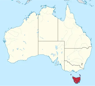
Tasmania's main island was first inhabited by Aboriginal peoples, who today generally identify as Palawa or Pakana. It is believed that Aboriginal Tasmanians became isolated from mainland Aboriginal groups around 11,700 years ago, when rising sea levels formed Bass Strait.
In 1803, Tasmania was permanently settled by Europeans as a penal settlement of the British Empire, partly to pre-empt French territorial claims during the Napoleonic Wars. At the time of British arrival, the Aboriginal population is estimated to have been between 3,000 and 7,000. Within three decades, however, this number declined drastically due to violent conflict, known as the Black War, and the spread of infectious diseases.
The Black War peaked between 1825 and 1831, resulting in the declaration of martial law for more than three years and causing the deaths of nearly 1,100 Aboriginal people and settlers.
Under British rule, the island was initially part of the Colony of New South Wales; however, it became a separate colony under the name Van Diemen's Land (named after Anthony van Diemen) in 1825. Approximately 80,000 convicts were sent to Van Diemen's Land before this practice, known as transportation, ceased in 1853.
In 1855, the present Constitution of Tasmania was enacted, and the following year the colony formally changed its name to Tasmania. In 1901, it became a founding constituent state of Australia (one of six) through the process of the federation of Australia.
Today, Tasmania has the second smallest economy of the Australian states and territories; economic activity involves principally tourism, agriculture, aquaculture, education, and healthcare. Tasmania is a significant agricultural exporter, as well as a significant destination for eco-tourism. About 42% of its land area, including national parks and World Heritage Sites (21%), is protected in some form of reserve. The first environmental political party in the world was founded in Tasmania.
Toponymy
Tasmania is named after Dutch explorer Abel Tasman, who made the first reported European sighting of the island on 24 November 1642. Tasman named the island Anthony van Diemen's Land after his sponsor Anthony van Diemen, the Governor of the Dutch East Indies. The name was later shortened to Van Diemen's Land by the British. It was officially renamed "Tasmania" in honour of its first European discoverer on 1 January 1856.
Tasmania was sometimes referred to as "Dervon", as mentioned in the Jerilderie Letter written by the notorious Australian bushranger Ned Kelly in 1879. The colloquial expression or nickname for the state is "Tassie". Tasmania is also sometimes referenced by its short-form name "Tas", mainly when written (eg, in business names, websites, addresses). TAS is also the Australia Post abbreviation for the state.
Names from Indigenous languages
In the constructed palawa kani language, the main island of Tasmania is called "Lutruwita", a name originally derived from the Bruny Island Tasmanian language. George Augustus Robinson recorded it as Loe.trou.witter, but also as Trow.wer.nar, probably from one or more of the eastern or Northeastern Tasmanian languages.
However, he also recorded this name for Cape Barren Island. In the 20th century, some writers used it as an Aboriginal name for Tasmania—spelled "Trowenna" or "Trowunna". It is now believed that that name is more properly applied to Cape Barren Island, which has had an official dual name of "Truwana" since 2014.
A number of palawa kani names, based on historical records of Aboriginal names, have been accepted by the Tasmanian government. A dozen of these (below) are 'dual-use' (bilingual) names, and another two are unbounded areas with only palawa names.
- Bilingual names
- Kanamaluka / Tamar River
- Kunanyi / Mount Wellington
- Laraturunawn / Sundown Point
- Nungu / West Point
- Pinmatik / Rocky Cape
- Takayna / The Tarkine
- Taypalaka / Green Point
- Titima / Trefoil Island
- Truwana / Cape Barren Island
- Wukalina / Mount William
- Yingina / Great Lake
- Palawa names
- Larapuna: an unbounded area centred on the Bay of Fires
- Narawntapu National Park (formerly Asbestos Range National Park)
- Putalina: an unbounded area centred on Oyster Cove (including the community of Oyster Cove)
There are also a number of archaeological sites with Palawa names. Some of these names have been contentious, with names being proposed without consultation with the Aboriginal community, or without having a connection to the place in question.
As well as a diverse First Nations geography, where remnants are preserved in rough form by European documentation, Tasmania is known as a place for unorthodox place-names. These names often come about from lost definitions, where descriptive names have lost their old meanings and have taken on new modern interpretations (e.g. 'Bobs Knobs').
Other names have retained their original meaning, and are often quaint or endearing descriptions (e.g. 'Paradise').
History
Physical history
The island was adjoined to the mainland of Australia until the end of the last glacial period about 11,700 years ago. Much of the island is composed of Jurassic dolerite intrusions (the upwelling of magma) through other rock types, sometimes forming large columnar joints. Tasmania has the world's largest areas of dolerite, with many distinctive mountains and cliffs formed from this rock type.
The central plateau and the southeast portions of the island are mostly dolerites. Mount Wellington above Hobart is a good example, showing distinct columns known as the Organ Pipes.
In the southern midlands as far south as Hobart, the dolerite is underlaid by sandstone and similar sedimentary stones. In the southwest, Precambrian quartzites were formed from very ancient sea sediments and form strikingly sharp ridges and ranges, such as Federation Peak or Frenchmans Cap.
In the northeast and east, continental granites can be seen, such as at Freycinet, similar to coastal granites on mainland Australia. In the northwest and west, mineral-rich volcanic rock can be seen at Mount Read near Rosebery, or at Mount Lyell near Queenstown. Also present in the south and northwest is limestone with caves.
The quartzite and dolerite areas in the higher mountains show evidence of glaciation, and much of Australia's glaciated landscape is found on the Central Plateau and the Southwest. Cradle Mountain, another dolerite peak, for example, was a nunatak. The combination of these different rock types contributes to scenery which is distinct from any other region of the world.[citation needed] In the far southwest corner of the state, the geology is almost wholly quartzite, which gives the mountains the false impression of having snow-capped peaks year round.
Aboriginal people
Evidence indicates the presence of Aboriginal people in Tasmania about 42,000 years ago. Rising sea levels cut Tasmania off from mainland Australia about 10,000 years ago and by the time of European contact, the Aboriginal people in Tasmania had nine major nations or ethnic groups. At the time of the British occupation and colonisation in 1803, the indigenous population was estimated at between 3,000 and 10,000.
Historian Lyndall Ryan's analysis of population studies led her to conclude that there were about 7,000 spread throughout the island's nine nations; Nicholas Clements, citing research by N.J.B. Plomley and Rhys Jones, settled on a figure of 3,000 to 4,000. They engaged in fire-stick farming, hunted game including kangaroo and wallabies, caught seals, mutton-birds, shellfish and fish and lived as nine separate "nations" on the island, which they knew as "Trouwunna".
European arrival and governance
The first reported sighting of Tasmania by a European was on 24 November 1642 by Dutch explorer Abel Tasman, who landed at today's Blackman Bay. More than a century later, in 1772, a French expedition led by Marc-Joseph Marion du Fresne landed at (nearby but different) Blackmans Bay, and the following year Tobias Furneaux became the first Englishman to land in Tasmania when he arrived at Adventure Bay, which he named after his ship HMS Adventure.
Captain James Cook also landed at Adventure Bay in 1777. Matthew Flinders and George Bass sailed through Bass Strait in 1798–1799, determining for the first time that Tasmania was an island.
Sealers and whalers based themselves on Tasmania's islands from 1798, and in August 1803 New South Wales Governor Philip King sent Lieutenant John Bowen to establish a small military outpost on the eastern shore of the Derwent River in order to forestall any claims to the island by French explorers who had been exploring the southern Australian coastline. Bowen, who led a party of 49, including 21 male and three female convicts, named the camp Risdon.
Several months later, a second settlement was established by Captain David Collins, with 308 convicts, 5 kilometres (3.1 miles) to the south in Sullivans Cove on the western side of the Derwent, where fresh water was more plentiful. The latter settlement became known as Hobart Town or Hobarton, later shortened to Hobart, after the British Colonial Secretary of the time, Lord Hobart.
The settlement at Risdon was later abandoned. Left on their own without further supplies, the Sullivans Cove settlement suffered severe food shortages and by 1806 its inhabitants were starving, with many resorting to scraping seaweed off rocks and scavenging washed-up whale blubber from the shore to survive.
A smaller colony was established at Port Dalrymple on the Tamar River in the island's north in October 1804 and several other convict-based settlements were established, including the particularly harsh penal colonies at Port Arthur in the southeast and Macquarie Harbour on the West Coast. Tasmania was eventually sent 75,000 convicts—four out of every ten people transported to Australia.
By 1819, the Aboriginal and British population reached parity with about 5000 of each, although among the colonists men outnumbered women four-to-one. Free settlers began arriving in large numbers from 1820, lured by the promise of land grants and free convict labour. Settlement in the island's northwest corner was monopolised by the Van Diemen's Land Company, which sent its first surveyors to the district in 1826.
By 1830, one-third of Australia's non-Indigenous population lived in Van Diemen's Land and the island accounted for about half of all land under cultivation and exports.
Black War
Tensions between Tasmania's Aboriginal and white inhabitants rose, partly driven by increasing competition for kangaroo and other game. Explorer and naval officer John Oxley in 1810 noted the "many atrocious cruelties" inflicted on Aboriginal people by convict bushrangers in the north, which in turn led to black attacks on solitary white hunters.
Hostilities increased further with the arrival of 600 colonists from Norfolk Island between 1807 and 1813. They established farms along the River Derwent and east and west of Launceston, occupying ten percent of Van Diemen's Land. By 1824 the colonial population had swelled to 12,600, while the island's sheep population had reached 200,000.
The rapid colonisation transformed traditional kangaroo hunting grounds into farms with grazing livestock as well as fences, hedges and stone walls, while police and military patrols were increased to control the convict farm labourers.
Violence began to spiral rapidly from the mid-1820s in what became described as the "Black War". Aboriginal inhabitants were driven to desperation by hunger – that included a desire for agricultural produce, as well as feeling anger at the prevalence of abductions of women and girls. New settlers motivated by fear carried out self-defence operations as well as attacks as a means of suppressing the native threat – or even in some cases, exacting revenge.
Van Diemen's Land had an enormous gender imbalance, with male colonists outnumbering females six to one in 1822—and 16 to one among the convict population. Historian Nicholas Clements has suggested the "voracious appetite" for native women was the most important trigger for the explosion of violence from the late 1820s.
From 1825 to 1828, the number of native attacks more than doubled each year, raising panic among settlers. Over the summer of 1826–1827 clans from the Big River, Oyster Bay and North Midlands nations speared stock-keepers on farms and made it clear that they wanted the settlers and their sheep and cattle to move from their kangaroo hunting grounds.
Settlers responded vigorously, resulting in many mass-killings. In November 1826, Governor Sir George Arthur issued a government notice declaring that colonists were free to kill Aboriginal people when they attacked settlers or their property, and in the following eight months more than 200 Aboriginal people were killed in the Settled Districts in reprisal for the deaths of 15 colonists.
After another eight months, the death toll had risen to 43 colonists and probably 350 Aboriginal people. In April 1828, Arthur issued a Proclamation of Demarcation forbidding Aboriginal people to enter the settled districts without a passport issued by the government. Arthur declared martial law in the colony in November that year, and this remained in force for over three years, the longest period of martial law in Australian history.
In November 1830, Arthur organised the so-called "Black Line", ordering every able-bodied male colonist to assemble at one of seven designated places in the Settled Districts to join a massive drive to sweep Aboriginal people out of the region and on to the Tasman Peninsula. The campaign failed and was abandoned seven weeks later, but by then Tasmania's Aboriginal population had fallen to about 300.
Removal of Aboriginal people
After hostilities between settlers and Aboriginal peoples ceased in 1832, almost all of the remnants of the Indigenous population were persuaded by government agent George Augustus Robinson to move to Flinders Island. Many quickly succumbed to infectious diseases to which they had no immunity, reducing the population further. Of those removed from Tasmania, the last to die was Truganini, in 1876.
The near-destruction of Tasmania's Aboriginal population has been described as an act of genocide by historians including Robert Hughes, James Boyce, Lyndall Ryan and Tom Lawson. However, other historians including Henry Reynolds, Richard Broome and Nicholas Clements do not agree with the genocide thesis, arguing that the colonial authorities did not intend to destroy the Aboriginal population in whole or in part.
Boyce has claimed that the April 1828 "Proclamation Separating the Aborigines from the White Inhabitants" sanctioned force against Aboriginal people "for no other reason than that they were Aboriginal". However, as Reynolds, Broome and Clements point out, there was open warfare at the time. Boyce described the decision to remove all Tasmanian Aboriginal people after 1832—by which time they had given up their fight against white colonists—as an extreme policy position.
He concluded: "The colonial government from 1832 to 1838 ethnically cleansed the western half of Van Diemen's Land." Nevertheless, Clements and Flood note that there was another wave of violence in north-west Tasmania in 1841, involving attacks on settlers' huts by a band of Aboriginal Tasmanians who had not been removed from the island.
Proclamation as a colony
Van Diemen's Land—which thus far had existed as a territory within the colony of New South Wales—was proclaimed a separate colony, with its own judicial establishment and Legislative Council, on 3 December 1825. Transportation to the island ceased in 1853 and the colony was renamed Tasmania in 1856, partly to differentiate the burgeoning society of free settlers from the island's convict past.
The Legislative Council of Van Diemen's Land drafted a new constitution which gained Royal Assent in 1855. The Privy Council also approved the colony changing its name from "Van Diemen's Land" to "Tasmania", and in 1856 the newly elected bicameral parliament sat for the first time, establishing Tasmania as a self-governing colony of the British Empire.
The colony suffered from economic fluctuations, but for the most part was prosperous, experiencing steady growth. With few external threats and strong trade links with the Empire, Tasmania enjoyed many fruitful periods in the late 19th century, becoming a world-centre of shipbuilding. It raised a local defence force that eventually played a significant role in the Second Boer War in South Africa, and Tasmanian soldiers in that conflict won the first two Victoria Crosses awarded to Australians.
Federation
In 1901, the Colony of Tasmania united with the five other Australian colonies to form the Commonwealth of Australia. Tasmanians voted in favour of federation with the largest majority of all the Australian colonies.
20th and 21st century
Tasmania was an early adopter of electric street lighting. Australia's first electric street lights were switched on in Waratah in 1886. Launceston became the first completely electrified city on the island in 1885, followed closely by the township of Zeehan in 1900.
The state economy was riding mining prosperity until World War I. In 1901, the state population was 172,475. The 1910 foundation of what would become Hydro Tasmania began to shape urban patterns, as well as future major damming programs. Hydro's influence culminated in the 1970s when the state government announced plans to flood environmentally significant Lake Pedder.
As a result of the eventual flooding of Lake Pedder, the world's first green party was established; the United Tasmania Group. National and international attention surrounded the campaign against the Franklin Dam in the early 1980s.
Tasmanian Enid Lyons became the first female member of the House of Representatives at the 1943 federal election and first female to serve in the federal cabinet. In May 1948, Margaret McIntyre achieved another milestone as the first female elected to the Parliament of Tasmania. Less than six months after her election, McIntyre died in the crash of the Lutana near Quirindi on 2 September 1948.
After the end of World War II, the state saw major urbanisation, and the growth of towns like Ulverstone. It gained a reputation as "Sanitorium of the South" and a health-focused tourist boom began to grow. The Princess of Tasmania began her maiden voyage in 1959, the first car ferry to Tasmania. As part of the boom, Tasmania allowed the opening of the first casino in Australia in 1968.
Queen Elizabeth II visited the state in 1954, and the 50s and 60s were charactered by the opening of major public services, including the Tasmanian Housing Department and Metro Tasmania public bus services. A jail was opened at Risdon in 1960, and the State Library of Tasmania the same year. The University of Tasmania also moved to its present location in 1963.
The state was badly affected by the 1967 Tasmanian fires, killing 64 people and destroying over 652,000 acres in five hours. In 1975 the Tasman Bridge collapsed when the bridge was struck by the bulk ore carrier Lake Illawarra. It was the only bridge in Hobart, and made crossing the Derwent River by road at the city impossible. The nearest bridge was approximately 20 kilometres (12 mi) to the north, at Bridgewater.
Throughout the 1980s, strong environmental concerns saw the building of the Australian Antarctic Division headquarters, and the proclamation of the Tasmanian Wilderness World Heritage Area. The Franklin Dam was blocked by the federal government in 1983, and CSIRO opened its marine studies centre in Hobart. Pope John Paul II would hold mass at Elwick Racecourse in 1986.
The 1990s were characterised by the fight for LGBT rights in Tasmania, culminating in the intervention of the United Nations Human Rights Committee in 1997 and the decriminalization of homosexuality that year. Christine Milne became the first female leader of a Tasmanian political party in 1993, and major council amalgamations reduce the number of councils from 46 to 29.
Following the Port Arthur massacre on 28 April 1996, which resulted in the loss of 35 lives and injured 23 others, the Australian Government conducted a review of its firearms policies and enacted new nationwide gun ownership laws under the National Firearms Agreement.