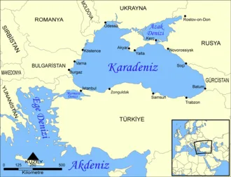
The Black Sea, not including the Sea of Azov, covers 436,400 km2 (168,500 sq mi), has a maximum depth of 2,212 m (7,257 ft), and a volume of 547,000 km3 (131,000 cu mi). Most of its coasts ascend rapidly. These rises are the Pontic Mountains to the south, the southwest-facing peninsulas, the Caucasus Mountains to the east, and the Crimean Mountains to the mid-north.
In the west, the coast is generally small floodplains below foothills such as the Strandzha; Cape Emine, a dwindling of the east end of the Balkan Mountains; and the Dobruja Plateau considerably farther north. The longest east–west extent is about 1,175 km (730 mi). Important cities along the coast include (clockwise from the Bosporus) the northern suburbs of Istanbul, Burgas, Varna, Constanța, Odesa, Yevpatoria, Sevastopol, Yalta, Kerch, Novorossiysk, Sochi, Poti, Batumi, Rize, Trabzon, Ordu, Samsun and Zonguldak.
The Black Sea has a positive water balance, with an annual net outflow of 300 km3 (72 cu mi) per year through the Bosporus and the Dardanelles into the Aegean Sea. While the net flow of water through the Bosporus and Dardanelles (known collectively as the Turkish Straits) is out of the Black Sea, water generally flows in both directions simultaneously: Denser, more saline water from the Aegean flows into the Black Sea underneath the less dense, fresher water that flows out of the Black Sea.
This creates a significant and permanent layer of deep water that does not drain or mix and is therefore anoxic. This anoxic layer is responsible for the preservation of ancient shipwrecks which have been found in the Black Sea, which ultimately drains into the Atlantic Ocean, via the Turkish Straits and the Aegean Sea into the Mediterranean Sea, and from it to the Atlantic proper through the Strait of Gibraltar.
The Bosporus strait connects it to the small Sea of Marmara which in turn is connected to the Aegean Sea via the strait of the Dardanelles. To the north, the Black Sea is connected to the Sea of Azov by the Kerch Strait.
The water level has varied significantly over geological time. Due to these variations in the water level in the basin, the surrounding shelf and associated aprons have sometimes been dry land. At certain critical water levels, connections with surrounding water bodies can become established. It is through the most active of these connective routes, the Turkish Straits, that the Black Sea joins the World Ocean.
During geological periods when this hydrological link was not present, the Black Sea was an endorheic basin, operating independently of the global ocean system (similar to the Caspian Sea today). Currently, the Black Sea water level is relatively high; thus, water is being exchanged with the Mediterranean. The Black Sea undersea river is a current of particularly saline water flowing through the Bosporus Strait and along the seabed of the Black Sea, the first of its kind discovered.
Name
Modern names
Current names of the sea are usually equivalents of the English name 'Black Sea', including these given in the countries bordering the sea:
- Abkhaz: Амшын Еиқәа, Amŝən Ejkʷa, IPA: [ɑmʂɨn ɛjkʷʰɑ]
- Adyghe: Хы Шӏуцӏэ, Xə Šʷʼucʼɛ, IPA: [xɘ ʃʷʼtsʼɜ]
- Armenian: Սեւ ծով, Sev cov, IPA: [sɛv t͡sɔv]
- Azerbaijani: Qara dəniz, IPA: [ɡɑˈɾɑ dæˈniz]
- Bulgarian: Чeрно морe, Čérno moré, IPA: [ˈt͡ʃɛrno moˈrɛ]
- Crimean Tatar: Qara deñiz, Къара денъиз, IPA: [qɑrɑ deŋiz]
- Gagauz: Kara deniz
- Georgian: შავი ზღვა, Shavi Zghva, IPA: [ʃavi zʁʷa]
- Laz and Mingrelian: უჩა ზუღა, Ucha Zugha, IPA: [ˈutʃä ˈzuɣä], or simply ზუღა, Zugha, IPA: [ˈzuɣä], "Sea"
- Persian: دریای سیاه, daryā-ye siyāh
- Romanian: Marea Neagră, pronounced [ˈmare̯a ˈne̯aɡrə] ⓘ
- Russian: Чёрное мо́ре, Chornoye more, IPA: [ˈtɕɵrnəjɪ ˈmorʲɪ]
- Turkish: Karadeniz, IPA: [kaˈɾadeniz]
- Ukrainian: Чо́рне мо́ре, Chorne more, IPA: [ˈtʃɔrne ˈmɔre]
Such names have not yet been shown conclusively to predate the 13th century.
In Greece, the historical name 'Euxine Sea', which holds a different literal meaning (see below), is still widely used:
- Greek: Εύξεινος Πόντος, Éfxinos Póndos, 'Hospitable Sea', [ˈefksinos ˈpondos]; the name Μαύρη Θάλασσα, Mávri Thálassa, 'Black Sea', [ˈmavɾi ˈθalasa], is also used. It is also known among Pontic Greeks as Πόντος Εὔξεινος Póntos Éfxeinos.
The Black Sea is one of four seas named in English after common color terms – the others being the Red Sea, the White Sea and the Yellow Sea.
Historical names and etymology
The earliest known name of the Black Sea is the 'Sea of Zalpa', so-called by both the Hattians and their conquerors, the Hittites. The Hattic city of Zalpa was "situated probably at or near the estuary of the Marrassantiya River, the modern Kızıl Irmak, on the Black Sea coast."
The principal Greek name Póntos Áxeinos is generally accepted to be a rendering of the Iranian word *axšaina- ('dark-colored'). Ancient Greek voyagers adopted the name as Á-xe(i)nos, identified with the Greek word áxeinos ('inhospitable').
The name Πόντος Ἄξεινος Póntos Áxeinos ('Inhospitable Sea'), first attested in Pindar (c. 475 BC), was considered an ill omen and was euphemized to its opposite, Εὔξεινος Πόντος Eúxeinos Póntos ('Hospitable Sea'), also first attested in Pindar.
This became the commonly used designation in Greek, although in mythological contexts the 'true' name Póntos Áxeinos remained favored.
Strabo's Geographica (1.2.10) reports that in antiquity, the Black Sea was often simply called 'the Sea' (ὁ πόντος ho Pontos). He thought that the sea was called the 'Inhospitable Sea' Πόντος Ἄξεινος Póntos Áxeinos by the inhabitants of the Pontus region of the southern shoreline before Greek colonization due to its difficult navigation and hostile barbarian natives (7.3.6), and that the name was changed to 'hospitable' after the Milesians colonized the region, bringing it into the Greek world.
Popular supposition derives 'Black Sea' from the dark color of the water or climatic conditions. Some scholars understand the name to be derived from a system of Turkic color symbolism representing the cardinal directions, with black or dark for north, red for south, white for west, and green or light blue for east. Hence, 'Black Sea' meant 'Northern Sea'.
According to this scheme, the name could only have originated with a people living between the northern (black) and southern (red) seas: this points to the Achaemenids (550–330 BC). However, this interpretation has been contested.[further explanation needed] The emergence of the current name in Greek may also be due to phonetic affinity in mare maius, mare Maggiore ('Great Sea') with the Greek word mavros ('black').
In the Greater Bundahishn, a Middle Persian Zoroastrian scripture, the Black Sea is called Siyābun. In the 10th-century Persian geography book Hudud al-'Alam, the Black Sea is called 'Georgian Sea' (daryā-yi Gurz). The Georgian Chronicles use the name zğua sperisa ზღუა სპერისა ('Sea of Speri') after the Kartvelian tribe of Speris or Saspers.
Medieval Russian chroniclers used the name Pontskoye more (Old Russian: Поньтьское море), although the Russian explorer Ignaty Smolnyanin (fl. 1389–1405) used the name 'Great Sea'.
Until the 15th–16th centuries, the name 'Russian Sea' (Russian: Русское море, Russkoye more) was also used. The name emerged in the 10th century following incursions into Constantinople, "because Russians used to trample the city often".
Other modern names such as Chyornoye more and Karadeniz (both meaning 'Black Sea') originated during the 13th century. A 1570 map Asiae Nova Descriptio from Abraham Ortelius's Theatrum Orbis Terrarum labels the sea Mar Maggior ('Great Sea'), compare Latin Mare major.
English writers of the 18th century often used Euxine Sea (/ˈjuːksɪn/ or /ˈjuːkˌsaɪn/). During the Ottoman Empire, it was called either Bahr-i Siyah (Perso-Arabic) or Karadeniz (Ottoman Turkish), both meaning 'Black Sea'.
Geography
The International Hydrographic Organization defines the limits of the Black Sea as follows:
On the Southwest. The Northeastern limit of the Sea of Marmara [A line joining Cape Rumili with Cape Anatoli (41°13'N)]. In the Kertch Strait. A line joining Cape Takil and Cape Panaghia (45°02'N).
The area surrounding the Black Sea is commonly referred to as the Black Sea Region. Its northern part lies within the Chernozem belt (black soil belt) which goes from eastern Croatia (Slavonia), along the Danube (northern Serbia, northern Bulgaria (Danubian Plain) and southern Romania (Wallachian Plain) to northeast Ukraine and further across the Central Black Earth Region and southern Russia into Siberia.
The littoral zone of the Black Sea is often referred to as the Pontic littoral or Pontic zone.
The largest bays of the Black Sea are Karkinit Bay in Ukraine; the Gulf of Burgas in Bulgaria; Dnieprovska Gulf and Dniestrovsky Liman, both in Ukraine; and Sinop Bay and Samsun Bay, both in Turkey.
Coastline and exclusive economic zones
- 1,329 — 172,484
- 2,782 — 132,414
- 800 — 67,351
- 354 — 35,132
- 310 (without Abkhazia 100) — 22,947
- 225 — 29,756
- 210 — –
- 5,800 — 460,084
Drainage basin
The largest rivers flowing into the Black Sea are:
- Danube
- Dnieper
- Don
- Dniester
- Kızılırmak
- Kuban
- Sakarya
- Southern Bug
- Çoruh/Chorokhi
- Yeşilırmak
- Rioni
- Yeya
- Mius
- Kamchiya
- Enguri/Egry
- Kalmius
- Molochna
- Tylihul
- Velykyi Kuialnyk
- Veleka
- Rezovo
- Kodori/Kwydry
- Bzyb/Bzipi
- Supsa
- Mzymta
These rivers and their tributaries comprise a 2-million km2 (0.77-million sq mi) Black Sea drainage basin that covers wholly or partially 24 countries: