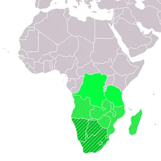
Defined by physical geography, Southern Africa is home to several river systems; the Zambezi River is the most prominent. The Zambezi flows from the northwest corner of Zambia and western Angola to the Indian Ocean on the coast of Mozambique. Along the way, it flows over Victoria Falls on the border between Zambia and Zimbabwe. Victoria Falls is one of the largest waterfalls in the world and a major tourist attraction for the region.
Southern Africa includes both subtropical and temperate climates, with the Tropic of Capricorn running through the middle of the region, dividing it into its subtropical and temperate halves. Countries commonly included in Southern Africa include Angola, Botswana, Comoros, Eswatini, Lesotho, Madagascar, Malawi, Mauritius, Mozambique, Namibia, South Africa, Zambia, and Zimbabwe.
In cultural geography, the island country of Madagascar is often not included due to its distinct language and cultural heritage.
Southern Africa has a more developed economy and infrastructure compared to the other regions of Africa, having a robust mining sector, comparatively developed secondary and tertiary sectors, and a strong manufacturing sector. Nevertheless, the region continues to struggle with inequality, crime, poverty, and the epidemic of HIV/AIDS in Africa, with Eswatini, Lesotho, Botswana, South Africa, and Namibia having the highest HIV/AIDS rates in the world.
Definitions and usage
In physical geography, the geographical delineation for the subregion is the portion of Africa south of the Cunene and Zambezi Rivers: Botswana, Eswatini, Lesotho, Namibia, South Africa, Zimbabwe, and the part of Mozambique that lies south of the Zambezi River. That definition is most often used in South Africa for natural sciences and particularly in guidebooks such as Roberts' Birds of Southern Africa, the Southern African Bird Atlas Project, and Mammals of the Southern African Subregion.
It is not used in political, economic, or human geography contexts because the definition cuts Mozambique in two.[citation needed]
UN scheme of geographic regions and the SACU
In the United Nations geoscheme for Africa, five states constitute Southern Africa:
 Botswana
 Eswatini (Swaziland)
 Lesotho
 Namibia
 South Africa
This definition excludes other countries in the region, and instead includes the Comoros, Madagascar, Malawi, Mauritius, Mayotte, Mozambique, Réunion, the Scattered Islands in the Indian Ocean (as a part of the French Southern Territories), Zambia, and Zimbabwe in Eastern Africa, Angola in Middle Africa (or Central Africa), and Saint Helena, Ascension, and Tristan da Cunha (under the name Saint Helena) in Western Africa, instead. Some atlases include Malawi, Zambia, and Zimbabwe in Central Africa instead of Southern or Eastern Africa.
The Southern African Customs Union, created in 1969, also comprises the five states in the UN subregion of Southern Africa.
SADC membership
The Southern African Development Community (SADC) was established in 1980 to facilitate co-operation in the region. It includes:
 Angola
- Botswana
 Comoros
 Democratic Republic of the Congo
- Eswatini (Swaziland)
- Lesotho
 Madagascar
 Malawi
 Mauritius
 Mozambique
- Namibia
 Seychelles
- South Africa
 Tanzania
 Zambia
 Zimbabwe
General usage
Other than the UN subregion, these countries and territories are often included in Southern Africa:[citation needed]
- Angola
- Comoros
 France
 Mayotte
 Réunion
 Scattered Islands in the Indian Ocean
- Madagascar
- Malawi
- Mauritius
- Mozambique
 United Kingdom
- Saint Helena, Ascension and Tristan da Cunha
- Zambia
- Zimbabwe
The Democratic Republic of the Congo is generally included in Central Africa, while Seychelles and Tanzania are more commonly associated with Eastern Africa, but these three countries have occasionally been included in Southern Africa, as they are the SADC members.
Geography
The terrain of Southern Africa is varied, ranging from forest and grasslands to deserts. The region has both low-lying coastal areas, and mountains.
In terms of natural resources, the region has the world's largest resources of platinum and the platinum group elements, chromium, vanadium, and cobalt, as well as uranium, gold, copper, titanium, iron, manganese, silver, beryllium, and diamonds.
Southern Africa is set apart from other Sub-Saharan African regions because of its mineral resources, including copper, diamonds, gold, zinc, chromium, platinum, manganese, iron ore, and coal. Countries in Southern Africa are larger in geographic area, except three smaller landlocked states: Lesotho, Eswatini (Swaziland), and Malawi.
The larger states — South Africa, Botswana, Mozambique, Zimbabwe, Zambia, Namibia, and Angola — all have extensive mineral deposits.
These widespread mineral resources make this one of the wealthiest regions of Africa with the greatest potential for economic growth. A chain of mineral resources in Southern Africa stretches from the rich oil fields in northwest Angola, east through the central diamond-mining region in Huambo Province, and into the Copper Belt region of Zambia and Congo.
A region of rich mineral deposits continues to the south called the Great Dyke in central Zimbabwe, through the Bushveld basin into South Africa. This extends southwest through the Witwatersrand and Northern Cape of South Africa toward the southern coast. Mining activity exists across the eastern region. Diamond mining is found in parts of Botswana and along the Namibian coast. Coal can also be found in central Mozambique, Zimbabwe, and northeast South Africa.
Climate
The climate of the region is broadly divided into subtropical in the north and temperate in the south, but also includes humid-subtropical, Mediterranean-climate, highland-subtropical, oceanic, desert, and semi-arid regions. Except for lower parts of Zambia and interior areas of Namibia and Botswana, the region rarely suffers from extreme heat.
In addition, the winter presents mostly as mild and dry, except in the southwest. Cool southeasterly winds and high humidity bring cool conditions in the winter. The Namib Desert is the driest area in the region.
Altitude plays an outsize role in moderating the temperatures of the South African Highveld, Lesotho, and much of Zambia and Zimbabwe. The prairie region of central and northeast South Africa, the country of Zimbabwe, and parts of Zambia are known as the veldt, divided into the Bushveld and Highveld. There are high temperatures and low rainfall within the Zambezi and Limpopo river valleys, probably due to the lower altitude.
The Western Cape has a Mediterranean vegetation and climate, including the unique fynbos, grading eastward into an oceanic climate along the Garden Route to Gqeberha and East London. The Namib and Kalahari deserts form arid lands in the centre-west, separating the highlands, woodlands, croplands, and pastures of the wetter and higher East from the Atlantic Ocean.
In addition, the Drakensberg and Eastern Highlands separate the highland areas and coastal plains centred on Mozambique in the north and KwaZulu-Natal in the south, the latter of which are often prone to flooding every few years. In the east, the river systems of the Zambezi and Limpopo basin form natural barriers and sea lanes between Mozambique, South Africa, and Zimbabwe.
Across most of southern Africa, apart from the Western Cape in South Africa, the major rainfall season is during the southern-hemisphere summer, from December to February. In the Western Cape, the rainfall maximum occurs from June through August.
There are a number of important rainfall-producing weather systems in southern Africa. These include tropical-extra-tropical cloud bands, tropical lows, and tropical cyclones, cut-off lows, and mesoscale convective systems. Winter midlatitude storms account for the June–August rainfall maximum in the western cape.
Year-to-year variability in rainfall, including drought, is associated with changes in global and regional sea surface temperatures. These include the El Nino Southern Oscillation, the Subtropical Indian Ocean Dipole, and changes in the Benguela Current region in the southeast Atlantic.
Future climate projections suggest that much of southern Africa will get hotter and drier in response to global climate change.
History
Prehistory
East and southern Africa are among the earliest regions where modern humans (Homo sapiens) and their predecessors are believed to have lived. In September 2019, scientists reported the computerized determination, based on 260 CT scans, of a virtual skull shape of the last common human ancestor to modern humans, representative of the earliest modern humans, and suggested that modern humans arose between 350,000 and 260,000 years ago through a merging of populations in East and South Africa. Homo naledi likely coexisted with modern humans in Africa about 300,000 years ago.
Kingdom of Mapungubwe
The Kingdom of Mapungubwe (c. 1075–c. 1220) was one of the earliest state in the South African region. It was located at between the Shashe and Limpopo Rivers. The name is derived from either Karanga and Tshivenda. The kingdom is thought to have existed as the first class-based social system within the region. Society was mainly centered around family and farming.
The kingdom would culminate to the Kingdom of Zimbabwe in the 13th century. And at its height the capital's population was about 5000 people. There are no written records from the kingdom and what historians and archeologists know of the state is from the remains of buildings.